”Geography Text of Kangwon Province (江原道誌)”
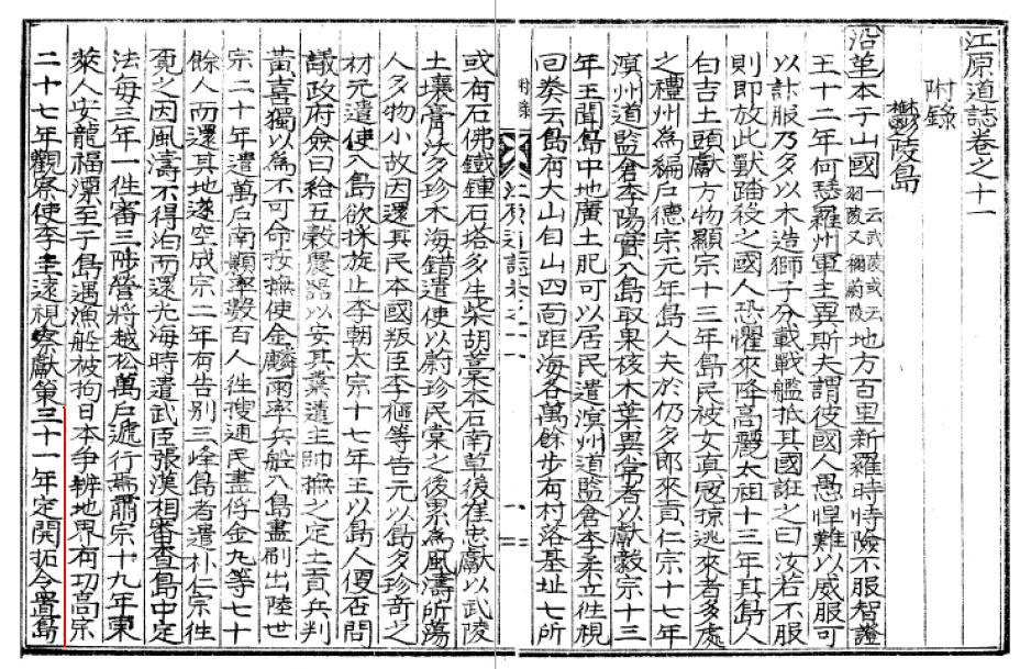
was first published in 1940, while Korea was under Japanese Annexation. I'm not sure if the text was written by Japanese or Korean, but it was written in old Chinese (漢文), which was very rare in Japan in 1940s. Though it was published years after Japan's incorporation of Takeshima into Shimane in 1905, it still shows many interesting points.
The most important point in the text is that it clearly states that "
Ulleungdo can be seen from Ulgin", Choson peninsula, not "Usando from Ulleungdo" like pro-Korean insist. In addition, it states Ulleungdo locates at the 135° 5′ E, which seems to be the mistake of at the 135° 55′ E, which is the Eastern longitude of Jukdo(竹島). ( Jukdo(竹島) was included in the section of "山川(Mountains and Rivers)", but not Dokdo, Usando nor Seokdo or any other name Korean claim as other names for Takeshima/Dokdo.)
江原道誌 巻之十一 附録 鬱陵島
・・・
〔位置及地勢〕 在蔚珍郡竹邊港東北海中三峰岌業撑空 南峯稍卑 風日清明 則峰頭樹木及山根沙渚 歴歴可見風便則二日可到全島絶壁周囲層岩峻急作三角形河川清冽原野雖少火山灰及腐植土甚肥沃距竹邊七十六浬東経一百三十度五分北緯三十七度三十分面積七千三百五十一町
------------------------------------------------
The Geography Text of Kangwon Province, Vol.11. Appendix Ulleungdo
・・・
(Location and Geography) It locates in the Northeastern sea of 蔚珍(Uljin)郡竹邊 harbour. Three peaks reach high into the sky. The southern peak gets gradually smaller. On clear, windy days, the trees on the summits and the sandy beaches at the base of the mountains are clearly visible. With a fair wind, they can be reached in two days. The whole island was surrounded by steep cliffs and covered by layers of rocks. The shape of the island is triangular. The clear rivers are running through the wild fields. Though there are not so much volcanic ashes and leaf molds, the land is fertile. It is 76 sea miles apart from 竹邊. It locates at the 135° 5′ E and 37° 30′ N. They have an area of 7351 cho (72.9 k㎡).
Actually, there is no mention of Usando at all in the sentence unlike other old documents, this time. So they are undoubtedly talking about the visibility of Ulleungdo from peninsula, that's for sure. It flatterly debunks Korean claim that the distance being talked about in the passage below from Geography Text of Korea's King Sejong (1454) was the distance between the two islands (Ullegungdo and Usan) rather than the distance between Uljin and the two island.
The Korean translation is simply wrong if you read whole text.
于山武陵二島 在縣正東海中 二島相去不遠 風日淸明 則可望見 新羅時 稱于山國 一云鬱陵島. 地方百里
-----------------------------------------------------
The two islands of Usan and Mu-leung are in the sea due east of the present "hyeon" (Uljin), and the distance between them is close enough that they are visible on a clear, windy day. In the time of Silla, they were called Unsan-guk or Ulleungdo. It has an area of 100 ri.
This is also supported by almost all other Korean old documents which states about the visibility of Ulleungdo. For example,
Sinjeung Dongguk Yeoji Seungram (新增東國輿地勝覽) (1530) also states that the islands of Usando/Ulleungdo (于山島 鬱陵島) were visible from the east coast of Korea. The text is almost same with Geography Text of Kangwon Province(1940), though Usando was described as same island as well.
于山島 鬱陵島 一云武陵 一云羽陵 二島在縣正東海中 三峯岌嶪撑空 南峯稍卑 風日淸明則峯頭樹木 及山根沙渚 歷歷可見 風便則二日可到 一說于山鬱陵 本一島 地方百里---------------------------------------------------------------------------
Usando/Ulleungdo are also called Muleung (武陵) or Uleung 羽陵). The two islands are in the sea due east of this village (Uljin). Three peaks reach high into the sky. The southern peak gets gradually smaller. On clear, windy days, the trees on the summits and the sandy beaches at the base of the mountains are clearly visible. With a fair wind, they can be reached in two days. It is said that Usan/Ulleung were originally one island. They have an area of 100 ri.
Second point is, it states that
the early immigrants are mainly from 江原慶尚両道, not 全羅南道 as some pro-Korean claim.
〔沿革〕 ...(高宗)三十一年定開拓令置島長自是江原慶尚両道沿海民多移住者光武四年改為鬱陵郡置郡守隆煕元年移属慶尚南道併合後大正三年移属慶尚北道四年改郡守為島司 --------------------------------
(History) ... In the year of 31 (of King Kojong)(1894), the order of development was issued. The head of island was appointed and coastal residents of both 江原 and 慶尚 province mainly immigrated. In the 4th year of 光武(1900), it was determined as Ulleungdo County and the County Magistrate (郡守) was appointed. In the first year of 隆煕(1907), the administration was moved to 慶尚南道, and after the annexation, it was again moved to the 慶尚北道 in the 3rd year of Taisho(大正)(1914). And the "County Magistrate" was changed to "Island Magistrate(島守)".
Thirdly, it states that
Usan was an old name for Ulleungdo. This is the only opportunity the name of "Usan" was mentioned in the text. "Usan" or "Usando" had been actually a name for Ulleungdo itself until Joseon Dynasy started to send official inspectors and gained more information around Ulleungdo in the late 1600s. Before that, Korean were not perfectly sure if there even really exit two islands.
After the inspection, Inspector Bak Seok-chang (朴錫昌) made the map of Ulleungdo (鬱陵島圖形) 1711 and placed Usando(=Jukdo) right east to Ulleungdo with a label, "So-called Usando, Grove(s) of Haejang Bamboo (所謂于山島 海長竹田)". It crystellized the conception that Usando was Jukdo, 2.2 kilometers off the east shore of Ulleungdo and almost all the Korean maps started to place Usando to the east of Ulleungdo. Before that, the location of two islands were confusional and "Usando" and Ulleungdo were recorded to be one island with different names / Two different islands in many Korean old documents. This historical coufusion remains even in official documents for a long time.
〔舊(古)島名〕 于山 羽陵 武陵 蔚陵 鬱陵
---------------------------------------------------------
(Old Name of Uleungdo) Usan, Ulleung, Mulleung, Ulleung, Ulleung
Lastly, as I already mentioned above, though the text mentions
観音島 and Jukdo(竹島/竹嶼) in the section of "山川(Mountains and Rivers)", but
not Dokdo, Usando nor Seokdo or any other name Korean claim other names for today's Takeshima/Dokdo. 〔山川〕弥勒峰 在島北海抜七百一米突 錐山 在島北海抜四百五十米突 孔岩 在島北 卵峰 在島北海抜六百十一米突 聖人峰 在島北海抜九百八十四米突 冠冑峰 在島北鎮山海抜七百米突 水雷岩 可頭峰 倶在島西海邊 老人峰 在島北台霞洞 待風坎 在島北玄圃西 千年浦 在島北羅里 竹岩 在島北天府北 島項嘴 在天府東海濱 観音島 在島東海濱
---------------------------------------------------------
(Mountains and Rivers) Maitreya(弥勒) peak locates at the north of the island with 701m of the sea level. A Gimlet Mountain locates at the north of the island with 450m of the sea level. 孔岩 locates at the north of the island. Egg peak locates at the north of the island with 611m of the sea level. A Saint peak(聖人峰) locates at the north of the island with 701m of the sea level.
After the name "Usando" started being officially dropped from Jukdo and the name of Jukdo,
Ulleungdo's neighboring island, which is only 2 kilometers off Ulleungdo's east shore, was officially recorded as Jukdo(竹島) by inspector 李奎遠 in 1882,
right after Kitazawa Masanari(北澤正誠), a Japanese official of MOFA concluded that "竹島(Takeshima)" is Jukdo in 1881, "
Usando", the old name for Jukdo, somehow started wondering again among Korean residents on Ulleungdo and they lost the location of "Usando".
This confusional naming shift around 1900 gave space for today's Korea's illogical claim "Usando was an old name for today's Takeshima/Dokdo", not Jukdo nor Ulleungdo, in addition to the name confusion by Japanese in Meiji due to the introduction of mismapped two Uleungdos in western maps, plus Japanese' newly giving Liancourt Rocks a name of Takeshima(竹島), which is the same Chinese as Korean Jukdo. But if the name "Usando" really didn't mean Jukdo, Korean in early 1900s must have named other islets around Ulleungdo or Takeshima/Dokdo as Usando, but they didn't, in reality. It practically means Usando didn't mean any other islets around Ulleungdo, except for Jukdo. Korean gave Takeshima/Liancourt Rocks, which Japanese introduced them in 1900s, a new name "Dokdo(独島)", which means "Sole/Lonely island", instead. The meaning of the name itself debunks Korea's claim that the Takeshima/Dokdo have been considered to be Ulleungdo's neighbouring island.
Those historical facts also tell us that Usando was almost certainly the old name for Jukdo(竹島 : Japanese write as 竹嶼), not today's Takeshima/Dokdo.
A lots of thanks to GTOMR for showing this important document.

 References;Q 2: What is Ulleungdo's largest neighboring island?Q 3: Why did old Korean maps show Ulleungdo as two islands?Q 4: Did King Sejong's geography text mention Dokdo?Q 5: Did Korea's 1530 "Sinjeung Dongguk Yeoji Seungram" mention Dokdo?1694 - Jang Han-sang (張漢相) Finds Sambongdo (三峯島)1711 - Bak Chang-seok's (朴昌錫) Map of Ulleungdo
(鬱陵島圖形)
1807 - May 12 - Lee Tae-gun (李泰根) Inspects Ulleungdo (日省録)
1881 - Kitazawa Masanari(北澤正誠), a official of MOFA concluded that
"Takeshima" is Jukdo in "A Study of Takeshima (Takeshima Kosho 竹島考証) "1882 - April 7 - King Kojong says Usando Neighboring Island of Ulleungdo (高宗 19卷, 19年 4月 7日 壬戌)
1906 - July - Korea Omits Dokdo from Uldo County (皇城新聞 「
鬱島郡의 配置顛末」)
1913 - June 22- Location of Usando Unknown in Early 1900s (毎日申報 "無人島探検中止")
1918 - Japanese Map of Ulleungdo (鬱陵島図 朝鮮総督府)
 This map is from the "Andree's Allgemeiner Handatlas", published in Leipzig, Germany by Velhagen & Klasing in 1904. You can see "Matsu Schima (Dagelet)", "Liancourt R (Hornet In.)" and "Oki Schima" in the "Japanisches Meer (Japanese Sea)". Although "Liancourt R" is too small to identify the colour, "Matsu Schima" (Ulleungdo) is coloured in brown - the same as Oki Schima and Japan's mainland. It means that the mapmaker believed that Liancourt Rocks, the rocks between Ulleungdo and Oki island, were in the Japanese territory. This is another example of many western maps that deny Korea's sovereignty over Liancourt Rocks in the early 1900's.