The map below is the "Aguk Chongdo" (我國摠圖) from the "Yeojido" atlas, which is believed to have been made sometime in the later part of the 18th century. The atlas is stored in Seoul National University's Gyujanggak Museum of Korean Studies.
One of the interesting things about the map is that it shows Ulleungdo (鬱陵島) with a neighboring island labeled as "Udo" (于島), instead of "Usando," which was much more common on old Korean maps.
The following is a closeup of Ulleungdo (鬱陵島) from the above map. Notice that it has a neighboring island labeled as "Udo" (于島).

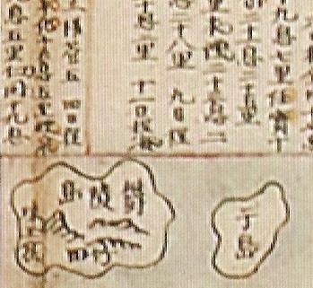
Below is another Korean map from possibly the 1800s that also shows Ulleungdo's neighboring island labeled as "Udo" (于島). The map was called "Jeop-yeok Jeondo" (鰈域全圖) and is stored in the U.S. Library of Congress.
The following is a closeup of Ulleungdo (鬱陵島) from the above map. Notice that its neighboring island was labeled as "Udo" (于島).

Another old Korean map that showed Ulleungdo's (鬱陵島) neighboring island labeled as "Udo" (于島) was the "Joseon Jeondo" (朝鮮全圖), from the "Haedongdo" (海東島) atlas, which is stored in the Samseong Art Center. The atlas is believed to have been compiled at the end of the 18th century.
Below is a closeup of the Ulleungdo section of the above map. Notice that Ulleundo's neighboring island was labeled as "Udo" (于島).
The following Korean map of Ulleungdo (鬱陵島) was an inspector's map that is believed to have been made sometime in the early 1800s or before. The map shows Ulleungdo with neighboring islands labeled as "Big Udo" (大于島) and "Small Udo" (小于島). The Big Udo was Ulleungdo's neighboring island of Jukdo (竹島), which is about two kilometers off Ulleungdo's east shore, and the Small Udo was Ulleungdo's neighboring island of Gwaneumdo (觀音島), which is only about 100 meters off Ulleungdo's east shore. The map is stored in Korea's Samcheok Museum.
The following is a closeup of the "Big Udo" (大于島) and the "Small Udo" (小于島) on the above map.
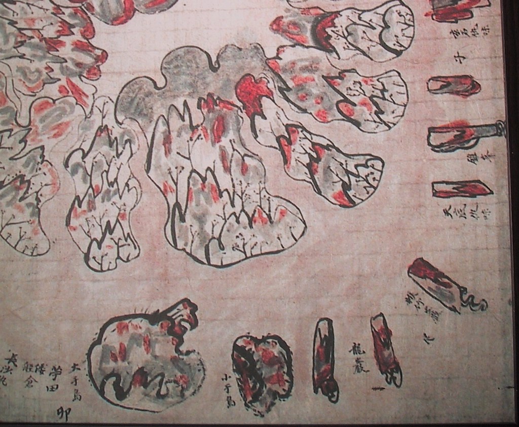
Below is a Korean inspector's map of Ulleungdo that is believed to have been made sometime in the early 1800s or before. The map shows Ulleungdo with two islands labeled as "Big Gando" (大干島) and "Small Gando" (小干島). The Chinese character "Gan" (干) was a common misspelling of "U" (于) and vice versa. Again the map shows that "Big Gando" was Ulleungdo's neighboring island of Jukdo (竹島), which is about two kilometers off Ulleungdo's east shore, and "Small Gando" as Ulleungdo's neighboring island of "Gwaneumdo" (觀音島), which is only about 100 meters off Ulleungdo's east shore. The map is stored in the National Library of Korea.

The following is a what the Takeshima Research Center (竹島問題硏究所) has said about some of the above maps
HERE in Question 5:
質問5
アメリカの議会図書館に、鬱陵島の隣島に于島と書かれた地図があるようだ(http://dokdo-or-takeshima.blogspot.com/2008/06/1800s-map-of-korea-jeop-yeok-jeondo.html?showComment=1212594900000)。これは三陟博物館と韓国中央図書館の鬱陵島圖形の大于島小于島と関係があるのではないか。
回答
貴重な情報をご提供くださりありがとうございました。ご教示いただいたブログ上で地図を確認しました。三陟市立博物館と韓国国立中央図書館所蔵の「鬱陵島圖形」の「大于島」「小于島」と関係があるというのは、(1)大于島、小于島が鬱陵島沿岸の小嶼(たぶん竹嶼と観音島)であることは間違いない、他方(2)朝鮮全図で鬱陵島の東側に于山島または于山という島を描く地図についてその于山島(于山)が独島だという主張とそれも竹嶼だという主張が対立していた、(3)今回紹介された米国議会図書館所蔵の地図は朝鮮全図でありながら鬱陵島の東側に描かれた一島を「于島」と表記しているので1の鬱陵島図形と2の多数の朝鮮全図をつなぐ役割を果たす、つまり2の類型の于山島も1で明らかなとおり竹嶼だということになる、だから重要だ、というご指摘だろうと思います。すでにビーバーズさんの発見にかかる「海長竹田/所謂于山島」と記した小嶼を描く鬱陵島図や、周囲に10朝鮮里の目盛が入っていて于山までの距離感がわかる青丘図など多くの朝鮮地図によって鬱陵島の東側に描かれた于山島(于山)が竹嶼であることが明らかになっていますが、今回ブログに掲載された地図により、18世紀以降の朝鮮地図にある于山が独島ではなく竹嶼であることが、また別の角度から裏付けられたということでしょう。(事務局:総務課)


This comment has been removed by the author.
ReplyDeleteThanks Gerry,
ReplyDeleteThese maps are interesting.
It is clear to all of us that Usando (Usan or Udo) was not Liancourt Rocks (Takeshima/Dokdo).
The lie, which was told for a long period since Rhee Syngman stole the island, that Liancourt Rocks (Takeshima/Dokdo) originally belonged to Korea was revealed.
The fact is that Korea didn't know well about Liancourt Rocks, they didn't own the rocks.
I hope that the fact will break the spell that was casted on Korean people for over 50 years.
BTW, the map shows that Korean people used to call the sea of east as 東海, the sea of west as 西海, and the sea of south as 南海. It is clear that these are local names for only Korean people and it is unreasonable to force some other countries to use these names.
ReplyDeleteIf they don't think it was unreasonable, then why don't they blame China to use the name of Yellow Sea instead of West Sea?
Hi, Pacifist.
ReplyDeleteDon't thank me; thank GTOMR because he was the one who pointed out to me that the 我國摠圖 also showed Ulleungdo's neighboring island as "Udo" (于島). If I had noticed that before, I had forgotten about it.
I have a feeling that all of these maps were made about the same time in the late 1700s or early 1800s, including the two inspector maps because they all show "Udo" (于島) as Ulleungdo's neighboring island.
Also, I think the maps were either influenced by or associated with the 1786 and 1794 Ulleungdo inspections, when there was a reference to a neighboring island of Ulleungdo called "Bangpaedo" (防牌島).
In the 1886 inspection, "Bangpaedo" (防牌島) was described as being "about three ri to the east of the big island" (束有防牌島距大島爲三里許), which means it was most likely referring to Ulleungdo's neighboring island of Jukdo (竹島).
In the 1794 inspection, "Bangpaedo" (防牌島) was described as being north of Jukdo, when viewed from Jeojeondong (楮田洞), which suggests it was Ulleungdo's neighboring island of Gwaneumdo (觀音島). The exact phrasing was as follows:
前有三島, 在北曰防牌島, 在中曰竹島, 在東曰瓮島。 三島相距, 不過百餘步, 島之周回, 各爲數十把, 險巖嵂, 難以登覽, 仍爲止宿。
There were three islands in front. The one to the north was called "Bangpaedo" (防牌島), the one in the middle "Jukdo," and the one to the east "Ongdo" (翁島). The distance between the islands was only about 100 paces, and the circumference of each was tens of pa (把). It was difficult to climb up and look because the rocks were steep and very towering.
The description the distances between and measurements of the islands in the 1794 report are confusing, but if we ignore the distances and focus on the fact that it said "Bangpaedo" (防牌島) was north of Jukdo (竹島), then it seems that Bangpaedo could have been Ulleungdo's neighboring island of Gwaneumdo (觀音島).
In Korean, "Bangpaedo" (防牌島) means "Shield Island," which ties the placename to the inspector's map that referred to Ulleungdo's neighboring islands of Jukdo and Gwaneumdo as "Big Gando" (大干島) and "Little Gando" (小干島). In Korean, the most common meaning for the Chinese character 干 (gan - 간) is "shield."
I think the reason the inspectors' maps referred to Jukdo and Gwaneumdo as "Big Gando" (大干島) and "Small Gando" (小干島) and "Big Udo" (大于島) and "Small Udo" (小于島) was because the inspectors were unsure of which of Ulleungdo's two neighboring islands was the Usando (于山島) referred to in historical documents.
Also, I think the reason they used "Big Udo" (大于島) and "Small Udo" (小于島) instead of "Big Usando" (大于山島) and "Small Usando" (小于山島) was because they were superstition about using 4-character names since the number 4 is unlucky. I also think that same superstition was why Ulleungdo (鬱陵島) was renamed "Uldo-gun" (鬱島郡), instead of Ulleungdo-gun (鬱陵島郡), when the island was made a county in 1900. As far as I know, three characters, not four, were used to name counties in Joseon Korea.
One more thing: I think the inspector's map in Samcheok Museum is an example of how the rock islets on the north side of Ulleungdo came to be drawn on the south side of the island.
前有三島, 在北曰防牌島, 在中曰竹島, 在東曰瓮島。 三島相距, 三島相距不過百餘歩
ReplyDeleteThere are similar record of ”百餘歩”on 西渓雑録
未時量●●涛到其島北岸則地絶険船舶所極難?仍于就其風残處?時下陸而山石巉岩連抱之木族立掩翳上不能見天下不能着●●泊凌風勢不順有難行?是齋島之東北有小岐立石九所而相距百歩許是 It shows northeast of Ulluengdo.
By the way, we know there are detailed ulleungdo map and stoneboard by Park Changho ,considered 1711. but...it is odd that I cannot find the description of his inspection on a records e.g. 實録 or 承政院日記 or 備辺司 and so on. Usually other inspector's inspection was stated on a records. but i couldn't find the report Park's inspection had done.
if someone know which website it is, please let me know.
The name of 搜討官 折衡將軍 三陟營將 兼 水軍僉節制使
ReplyDeleteis not Park Changho , but 朴錫昌 Park Seok-chang, as 「鬱陵島図形」(1711)says.
Its very confusing the name is sometimes written like as 朴昌錫.
So if you search 朴錫昌, you may find the name in 實録 or 承政院日記 or 備辺司.
(I expect your finding very much as usual)
If you don’t find, it will make another interesting WHY.
Thanks matsu. I did misunderstanding only his name pronunciation. Ofcourse I serched those keywords e.g. 朴錫昌/朴昌錫/三陟營將/三陟僉使/ 越松萬戶 /鬱陵/蔚陵/蔚珍/平海 and so on
ReplyDeletebut I cannot find any "order document to him" and the record "he did report after inspection"
though there are some records about "朴錫昌” around 1690-1710 which is unrelated of inspection.
If Korean want to deny his map Usando is jukdo-Boussole Rock, it is best way to check if there are inspection report by him or not( unless it is detailed report or not.)
And if they want to deny Big-Usando-Jukdo and Small-Usando-Gwaneumdo on Samchok and National library detailed Ulleungdo maps, also it would be best way to serch and analysis which year, and related and linked detailed report with this maps. But....why they don't do that?
I totally forgot about this. Shimane Web Takeshima Center talked about this "Udo" (于島) in "Jeop-yeok Jeondo" (鰈域全圖). I'll translate it later.
ReplyDelete【質問5】
アメリカの議会図書館に、鬱陵島の隣島に于島と書かれた地図があるようだ(http://dokdo-or-takeshima.blogspot.com/2008/06/1800s-map-of-korea-jeop-yeok-jeondo.html?showComment=1212594900000)。これは三陟博物館と韓国中央図書館の鬱陵島圖形の大于島小于島と関係があるのではないか。
〈回答〉
貴重な情報をご提供くださりありがとうございました。ご教示いただいたブログ上で地図を確認しました。三陟市立博物館と韓国国立中央図書館所蔵の「鬱陵島圖形」の「大于島」「小于島」と関係があるというのは、(1)大于島、小于島が鬱陵島沿岸の小嶼(たぶん竹嶼と観音島)であることは間違いない、他方(2)朝鮮全図で鬱陵島の東側に于山島または于山という島を描く地図についてその于山島(于山)が独島だという主張とそれも竹嶼だという主張が対立していた、(3)今回紹介された米国議会図書館所蔵の地図は朝鮮全図でありながら鬱陵島の東側に描かれた一島を「于島」と表記しているので1の鬱陵島図形と2の多数の朝鮮全図をつなぐ役割を果たす、つまり2の類型の于山島も1で明らかなとおり竹嶼だということになる、だから重要だ、というご指摘だろうと思います。すでにビーバーズさんの発見にかかる「海長竹田/所謂于山島」と記した小嶼を描く鬱陵島図や、周囲に10朝鮮里の目盛が入っていて于山までの距離感がわかる青丘図など多くの朝鮮地図によって鬱陵島の東側に描かれた于山島(于山)が竹嶼であることが明らかになっていますが、今回ブログに掲載された地図により、18世紀以降の朝鮮地図にある于山が独島ではなく竹嶼であることが、また別の角度から裏付けられたということでしょう。(事務局:総務課)
Thank you, Kaneganese. I have added to the post what the Takeshima Research Center said about some of the maps.
ReplyDeleteMy translation is this. (I hope it makes sence to everyone.)
ReplyDeleteQ5 : The map "Jeop-yeok Jeondo" (鰈域全圖) stored in Library of Congress in the United States This might be related to "大于(干)島" and "小于(干)島" in the inspectors' Ulleungdo maps("鬱陵島圖形") stored in Samcheok Museum and Korean National Library.
A. : The point of question is summerized below.
(1) "大于(干)島" and "小于(干)島" on the east shore of Ulleungdo in "鬱陵島圖形"are almost likely to be the islets around coast of Ulleungdo (probably Jukdo and Kwanungdo, resectively).
(2) On the other hand, as for Usando/Usan, on the east shore of Ulleungdo, in Korean old maps "朝鮮全図", there are two conflicting opinion (Korea : Usando/Usan = Dokdo, Japan : Usando/Usan = Jukdo).
(3) This map, "Jeop-yeok Jeondo" (鰈域全圖), is "朝鮮全図", meanwhile, an island on the east shore of Ulleungdo is labelled as "于島". Therefore, this map is playing a key role to tie "Map of Ulleungdo" ("鬱陵島圖形") to many "Complete Map of Korea"("朝鮮全図"), in other words, Usando/Usan type islands in "Complete Map of Korea"("朝鮮全図") are Jukdo.
As Mr. Bevers already pointed, the map of Ulleungdo which labelled Usando as 「海長竹田/所謂于山島」 and the map like "青丘図" which is telling the distance between Usando and Ulleungdo by its 10 Choson ri scale, practically shows that Usando(Usan) is nothing but Jukdo. This map, is another proof that Usan in the Korean maps after 18C are not Dokdo, but Jukdo.
Gerry,
ReplyDeletePlease scan and upload from Lee Santae's book as follow map;
17C.八道全図
Above scanning image is not clear. also please inform the page number.
I guess this is one of the oldest realistiic Ullengdo desigin and rare type in 17th Century.
This map would have new special meaning. later I will write it.
This map is interesting because there is a writing beside Ulleungdo which reads "自此●(凶?)東●(至?)日本".
ReplyDeleteIt may mean that "If you go east from this place, you will reach Japan". It may indicate that Korean people in those days believed that Ulleungdo was their eastern limit.
Surely,It can be read "自此以東○日本".
ReplyDeleteIt means that "There is Japan at the east of this island (Ulleungdo).
It shows that Korean people did not know about Liancourt Rocks (Takeshima/Dokdo) in those days.
GTOMR,
ReplyDeleteThat copy of the 八道全図 is a scan from Lee's book, and it is probably as good as you are going to get. The map is on Page 25 of Lee's book. He lists it as being stored in Koryo University Museum.
As for the very interesting writing to the southeast of Ulleungdo, I would just a 方 to what Pascist and Chaaimy wrote:
自此以東方日本
Japan is east of this island
Wow! This supports what is written in the Ulleungdo Sajeok and what is written in the 1714 document. Since Usando is drawn to the west of Ulleungdo on the map, there can be no misunderstanding that the mapmaker believed the territory to the east of Ulleungdo to be Japanese territory.
I will do a post on this.