- Link to Original Document & Map
- Link to Japanese Transcription of the Document
- Link to Korean Translation of the Document
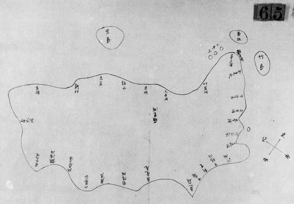
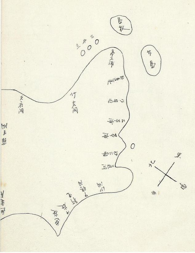
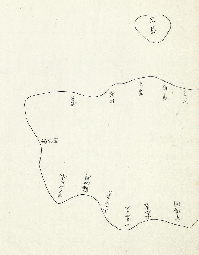
Below is the copy of the above map that was sent to the Japanese Ministry of Foreign Affairs. Notice that the placenames were written somewhat more clearly.
Gerry,
ReplyDeleteI think we should add the traced map and the list of the mistakeswe found to this post and send a massage to Kyujunguaak staff to correct them or get rid of that strange map from their website. As far as I see, it looks like those mistakes are not intentionally, but just honest mistakes. But especially, the difference of the direction is seriously wrong, since if it is as they traced (One big island + 5-6 small island in south of Ulleundo ), it means this map has strong connection to the old Korean maps, 皇城新聞 article in 1899, and 1900 Imperial Ordinance No.41, which is not true.
Dear Gerry,
ReplyDeleteIt seems that 島牧 (tou-boku, tou-moku, or whatever) is right. But I still wonder why they called it as an "island neck" although the map indicates that it was an island.
機密京第一七號
ReplyDelete小官五月三十日警部渡邊鷹次郞及當領事館附巡査高倉純雙同肱岡登之進竝ニ佐藤潤象ヲ從ヒ材木取調ノ爲メ內部視察官禹用影及釜山監理署主事金冕秀ト二十日蒼龍號ニ便乘シ鬱陵島ニ向ヒ出發翌三十一日着上陸翌日ヨリ三日間島監裵季周ノ邸ニ於テ受命調査事項ニ就キ雙方立會日本人及島監ヲ取調ヘ餘日ヲ以テ山林其他ノ雜項ヲ調査シ六日歸途ニ就キ翌七日歸釜仕候受命調査報告及其他ノ雜項ハ次便ニテ送付可仕候玆ニ別紙鬱陵島調査槪況竝ニ同島山林調査槪況及御送付候間御閱覽相成度此段申進候 敬具
明治三十三年六月十二日
鬱陵島山林調査槪況
(機密京第一七號附屬書)
鬱陵島ハ韓國江原道ニ屬シタル島嶼ニシテ松島又ハ竹島ト稱シ(東經百三十度八分二厘北緯三十七度五分)釜山ヲ距ル東北百八十哩境港ヲ距ル西北二百哩隱岐ヲ距ル百四十哩ニシテ東西凡六哩强南北凡四哩强海面ヲ拔ク約四千尺周圍凡二十哩峻硝澆确峯巒重疊鬱蒼タル天然ノ森林ニシテ日光ヲ見サルノ部分其半ヲ占メ老樹衰憊腐朽ニ屬スルノ今所モ尠カラサルナリ陸地ヲ距ル百四十哩ノ小島ナルヲ以テ海底深ク濃藍色ヲ呈シ風波常ニ甚タシク殊ニ灣形ヲナシタルケ所ナク船舶ノ碇泊ニ便ナラス
見込面積凡九千三百三十一町貳反步內凡六千九百九十八町四反步ハ山林地ニシテ(千四百九十八町四反步ハ谿及岩石ニシテ五千五百町步ハ樹林ノ見込)凡二千三百三十二町八反步ハ無立木地ニ屬シ五百町步ハ切替畑地千八百三十二町ハ反步ハ不毛地其他ノ見込ナリ
山林ハ針葉濶葉ノ混淆天然林ニシテ濶葉樹大部分ヲ占メ其樹種ハ山毛欅, モミジ, タブ, 椿栂, 欅, ビヤクダン, モチ, 櫻, アラゝキ, オゝバク, テンポナシ, 桑, 五葉松, 榎, 等ニシテ欅ハ其質最モ良好木理緻密ナルモ梅ハ疎惡ナリ其他ハ日本種ニ異ナル事ナシ
運搬ハ傾斜最モ甚シキ海面ヲ距ル遠カラス谿水又ハ雨水ニ依リ附近沿岸ニ搬出ノ便アリ
旣往欅伐木ノ槪況ハ明瞭ナラサルモ今ヲ距ル十三年前日本ヘ大木ヲ出シタリト云フ蓋シ本願寺建築ノ用材ナランカ其伐木ノ根株點々實見セリ其當時ハ日本人一千人モ渡來シ伐材シタリト云ヘリ
明治三十年ニ苧浦ニテ日本人島監ヨリ貰ヒ受ケ一本ヲ伐採シ二千五百才餘ノ板材ヲ日本ヘ輸送シ韓人(北浦シヨンゴサンヨリ伐材)伐採シ三千才ノ板材ヲ日本ニ輸送セリ
同三十二年ニハ二十八本日本人ニテ伐採シ拾萬才餘ノ板材ヲ日本ヘ輸送セリ此價一才該島ニテ七錢トシ七千圓ナリ
同三十三年ニハ韓政府ノ公文ニ基キ三十二年十一月島民ト利益分配ノ契約濟ニ係ル八十本ノ中五十六本伐採シ旣ニ五萬才餘ハ日本ヘ輸送セリト云フ
欅材ノ製材費ハ一才(一寸角長七尺)貳錢五厘ニシテ山床ヨリ海岸迄運搬費貳錢乃至貳錢五厘海岸ニテ賣價七錢トスレハ貳錢ノ利益トナル日本マテノ運賃ハ凡貳錢ナリ
黐皮ニテ黐ヲ製造シ日本ヘ輸送シタルハ其總計七千五百貫ニシテ此價三千四百圓ナリ其年別ハ下ノ如シ三十年二千五百貫此價千圓(十貫四圓)三十一年三千貫此價千二百圓(十貫四圓)三十二年千五百貫此價九百圓(十貫六圓)三十三年五百貫此價三百圓(十貫六圓)ナリ
欝陵島立木見込調表
ReplyDelete(See Original text)
考
一. 本表ハ目量總面積九千三百三十一町二反步ト假定シ內二千三百三十二町八反步ノ無立木地則チ畑地及不毛地其他トシ殘六千九百九十八町四反步ノ山林地ノ內谿川及岩石占有面積千四百九十八町四反步ヲ控除シ全殘五千五百町步ノ樹林ト見做シ凡全林ノ十分ノ一蹈査目量ノ結果ニ依リ立木ノ見込ヲ定メタメタルモノナリ
本表ノ立木總數ハ目通面三尺以上ノモノ五十萬一千六百本トナルモ前項ノ査定法ニヨリ僅カニ四日間ノ調査ニ過キサルヲ以テ素ヨリ精竅ナル能ハス
鬱陵島調査槪況
第一. 位置及地勢
欝陵島ハ釜山ヲ距ル百八十哩元山ヲ距ル百八十哩日本ノ隱岐ヲ距ルコト百四十哩ノ海洋ニ孤立セル一島嶼ニシテ周回凡ソ十里全島島皆巖石ヲ以テ數多大小高低ノ山ヲ築キ無數ノ深谿其間ニ縱橫シ山巓ヨリ谿間ニ至ル迄欝蒼タル樹木ヲ以テ蔽ハレ極メテ壯觀ナリ沿岸一帶皆殆ント懸崖絶礕ニシテ港灣殆ント無ク風浪ノ際ハ船舶ノ難ヲ避クルニ由ナシ僅カニ道洞ト稱スル所ニ於テ絶礕ノ間ニ極メテ狹キ一小港アリ日本ノ風帆船二百石積以下ノ者ハ此處ニ來リテ碇ヲ下スト雖トモ風浪ヲ防クニ足ラサルヲ以テ皆之ヲ陸ニ引揚ケ居レリ故ニ汽船ノ如キハ穩波ニ乘スルニ非サレハ該島ニ至ルコトハ甚タ危險ナリ此ノ如キヲ以テ元山釜山若クハ日本ノ境若クハ馬關等最モ該島ニ接近セル場所トモ舟揖ノ往來至テ少ク所謂絶海ノ孤島ナリ陸上ノ交通モ亦多クノ山谷ヲ上下セサル可カラサルヲ以テ殆ト道路ト稱スヘキモノナクーノ村ヨリ他ノ村ニ至ルニハ極メテ困難ナリ
第二. 産物
海産物トシテハ若布天草鮑魚ノ類ニシテ其産額ハ多カラス漁業ハ海底槪シテ深ク且ツ巖石多キヲ以テ全ク見込ナシ
農産物トシテハ大豆麥及馬鈴薯ノ類ナリ然レトモ全島山ノ集合ニシテ全ク平地ナキヲ以テ島民ハ山ノ半腹ニ畠ヲ開キ蒔種セサル可ラス畠地ノ面積ハ餘マリ廣カラス而カモ旣ニ開墾シ盡シテ寸尺ノ餘地ナキカ如シ大豆ノ總産額ハ年平均凡ソ五千石ニシテ內平均三千石ハ重モニ之ヲ日本ニ輸出ス其代價日本相場平均二萬圓位ナリ麥ノ産額ハ其數量ヲ詳ニスル能ハスト雖トモ島民二千五百餘ノ常食用ニ供給シテ殆ント餘剩ナク僅カニ百石乃至百五十石ノ輸出ナリ
馬鈴薯ハ島民ノ副食物トシテ用ユルモノニシテ産額多カラス林産物ハ實ニ欝陵島ノ價ヲ爲スモノニシテ樹木ノ重モナル者ハ槻木·白檀, 栂, ブナ, タブ, 黐, 桑等ナリ
槻木ハ其質頗ル佳良ニシテ日本ニ多ク其比ヲ見スト云フ然レトモ其大ニシテ價アルモノハ旣ニ殆ント伐採シ盡シテ六丈以上一丈五尺以下ノ者ニシテ現在スルモノ僅カニ百五十株ニ過キス其內九尺內外ノモノ最モ多シ而シテ其製材ニ適スルハ又三分一弱ナラン三尺以上六尺以下ノ者ハ其數少カラサルモ小ナルヲ以テ價廉ナリ要スルニ槻木ハ今後餘マリ見込ナシ
白檀ト稱スルモ印度地方ニ生長スル者ト其質ヲ異ニシ香氣少ク眞ノ白檀ト稱スルヲ得サル由ニテ從テ價廉ニシテ又絶礕ノ上ニ在ルヲ以テ伐採困難ナリ株數ハ少ナカラサル見込ナリ
栂ハ其數甚タ多ク且ツ大ナリ然レトモ樹質良好ナラス木材トテモ價値ナシ
黐ハ以前ハ多カリシモ今日ハ切リ盡シテ少ナシ質ハ上等ナリ其他ハ略ス
第三. 輸出入
輸出品ノ重モナルモノハ槻木材ハ別トシテ大豆·麥·胡太·鮑·天草·黐等ナリ
三十年三十一年三十二年ノ三年間ノ平均ノ輸出高ヲ日本相場ヲ以テ示セハ一年平均
大豆 二萬圓 韓人ノ産出スルモノ
胡太 七百七十圓
麥 九百六十圓
鮑 二千九百六○圓 日本人自ラ取リテ持歸ルモノ
天草 一千二百圓
黐 六千圓
合計三萬○一百六○圓
輸入品ハ綾木綿金巾綿其他飮食用品ニシテ三十一年及三十二年ノ平均輸入高七千圓內外ナリ
輸入品ハ在嶋日本人カ自用ニ供スル外韓人ノ大豆胡太麥等ト交換スルナリ
仕出地及仕向地ハ島ハ道洞日本ハ境, 馬關, 鶴賀, 濱田等ニシテ境ハ其七分ヲ占ム
第四. 島治
島民戶數五百二十餘人口二千五百有餘島監ナル者アリテ島治ヲ司ル島監ノ下ニ各村ニ村長ナルモノアリ村ノ世話役ナリ島監役場ハ今マ道洞ト稱スル所ニアリテ現島監ヲ斐季周ト稱ス韓廷ヨリ一文ノ俸給ヲ受ケス又嶋民其他ヨリ收入少キヲ以テ貧窮ニシテ無勢力ナリ加フルニ權力ナキヲ以テ島民ノ八分ハ尊敬シテ其命ニ服セス故ニ治績擧ラス島民相互ノ間ハ隣保相親シミ能ク共同生存ノ秩序ヲ保テリ斐島監ハ日本ニ三度到リタルコトアリテ稍々日本語ヲ解シ日本人ノ爲メニ頗ル便利ナリト雖トモ彼レ日本ニ到リ槻木材ノ日本ニ於ケル價値ヲ知レル故ニ常ニ自ラ伐採シテ日本人ノ一人ニ結托シ利益ヲ專ニセントノ考アリ昨年以來彼レカ韓廷內部ニ向テ日本人槻木盜伐云々ヲ報告シ又ハ島民槻木ヲ視ルコト生命ノ如シナト云ヘルハ全ク右ノ魂膽ニ出ルモノニシテ島民ハ槻木ノ價ヲ解セス山ニ入リテ見ルニ皆之ヲ薪炭用トシテ伐採シ居レリ此ノ如キヲ以テ島監ト日本人ノ間ハ感情面白カラス
第五. 在島日本人
在島日本人ハ重モニ島根縣人ナリ其數ハ年ト時ニ依リテ增減アリ一定セス現在ノ數ハ百人內外ナリ在嶋日本人ノ話ヲ聞クニ日本人ノ該島ニ初メテ來リタルハ明治二十四年黐製造ノ爲メ七人渡航シ來リタルヲ始メトシ其後續テ入リタルモ二十五年ヨリ二十八年迄ハ明ナラス二十九年以後二百人內外在嶋セリ重モニ欅木伐採者竝ニ其附屬員ナリ目下在島ノ百人ハ日本ヨリ元山若クハ釜山ニ向ツテ渡航ノ途中天氣ノ都合ニ依リ寄港シタル者及態々來島シタル者ナルカ船舶ノ出港免狀及旅券ハ多ク元山若クハ釜山宛テナリ彼等ハ道洞ト稱スル村ヲ中心トシテ集マリ其他各所ニ散在ス彼等ハ一ノ組合ヲ作リ幹事ヲ置キテ相互ノ秩序ヲ維持ス
島監斐季周ニハ餘マリ敬服セサル風ナレトモ別ニ亂暴等ヲ爲シタルコトナシ殊ニ前幹事片岡吉兵衛ナルモノ及現幹事松本繁榮ハ能ク斐島監ト折合ヒ居レリ島民トハ至テ感情宜敷島民ハ日本人ニ依リテ多クノ便利ヲ與ヘラレ居ルコトヲ喜ヒ居レリ島民ノ衣服地タル綾木綿金巾等ハ皆日本人ノ輸入ニ係ル本國トノ往來ハ皆日本形風帆船ニ依ル現在寄港中ノ者十一艘ヲ見タリ平均百石積內外ナリ港ナク風浪高キヲ以テ往來至テ少シ
第六. 欝陵島ニ對スル將來ノ見込
前來述ヘタル所ニ依ルニ海産物ハ見込甚タ少ナク加フルニ近頃鮑天草大ニ其數量ヲ減シタル模樣ニテ在島日本人ノ話ヲ聞クニ器械船一艘以上ハ見込ナシトノコト農産物ハ大豆ヲ除キテ他ニ見込ナシ之レトテモ僅カニ年輸出額三千石ニ過キス尙將來其産額ヲ增加スル見込ナシ最モ有望ナリト稱スル山林中最モ價値アル槻木ハ旣ニ六尺以上ノモノハ切盡サレ現存スル者ハ其數二百ニ滿タス而カモ其內中心腐敗シテ製材ニ適セサルモノ少ナカラス木挽ノ話ヲ聞クニ大低來年一配ニ切リ盡ス見込ナリトノコト
栂ハ數多ク且ツ大ナレトモ樹質上等ニアラス其他ハ價値アルモノトシテ數フルニ足ラス
以上ノ如キヲ以テ欝陵島ハ將來甚タ有望ナラス故ニ現在在嶋ノ日本人ヲ立退カシメ尙且ツ將來ノ入島ヲ禁スルモ其失フ所ハ實ニ僅少ノ額ニ止マルヘシ然レトモ今一年間在嶋日本人問題ヲ未決ニ付シテ差支ナキ方法アラハ槻木ハ大抵伐リ盡サレン
Kaneganese,
ReplyDeleteFirst, I do not think the site is Kyujanggak, but the National Institute of Korean History.
Second, I would rather not post the traced map because people may just look at the map and copy it without reading about the mistakes on it. Then the bad map it spread even wider on the NET.
Third, I might post something to their bulletin board after I make sure which are mistakes and which are not.
What mistakes did you notice on the map? These are some of the placename mistakes I noticed:
昌洞, not 呂洞
停石浦, not 高在浦
臥達里(吏), not 臥建失
窟岩, not 窟石
山幕谷, not 山蕗谷.
Do you agree that those are mistakes? Are there any others?
Pacifist,
Yes, it is a strange name for an island, so, maybe, originally it was just the name of the cape. I wonder, too.
Gerry,
ReplyDelete窟岩, not 窟石
山幕谷, not 山蕗谷.
昌洞, not 呂洞
錘山,not 銅山
I dont think therse are牛膓洞 and
邊嶺...
It may be 臥達吏, not 臥建失<--I cannot confirm it.
It may be 亭石浦 or 高在浦Gojae-po <--I cannot confirm because too small charactor..
Cnsidering from the report of 1900 and 1902,It seems to be 亭石浦. But I heard, but sorry no source, Gwaneumdo was called "Ggak-sae".
There are other reports from 東萊監理署理主事 金冕秀 to 議政府大臣朴齊純, based on the report by 禹用鼎, at the same terms of Akatsuka on 9th of June 1900 ,which reports some brefing report about population/adress list,but i cannot read it in the link,local products, and briefly geography info on Ulleungdo.But I think this report is less information than 鬱陵記.And I wonder when he wrote 鬱陵記,he hadn't attached maps for more understandings.
If I read the text below without any knowledge and map, I cannot understand it.
在天府洞上雙燭巖屹立千丈合上而下開可容帆船出入
於其間為島中ノ一奇観也蓋此島(there is no 亭石浦 report.)
on 1902 report
テツセミ島ハ臥達里ノ前洋ニ在リ本邦人之ヲ竹島と俗称ス周回三拾X余「タブ」女竹繁スト雖トモ飲料水ナキヲ以テ移住スル モノナシト云フ、又亭石浦ノ海上ニ雙燭石及島牧ノ島峡アリ周回二十丁本邦人之ヲ観音島と称し其岬ヲ観音岬と云ヒ其ヲ観音ノ瀬戸ト呼ヘリ、又雙燭石ハ三岩高 ク樹立スルニヨリ三本ノ名アリ
---
By the way Now I realised the phraze of "大小六島あり其中著名なるを于山島(日本人は松島と名く)竹島といふ" on 朝鮮開化史1901.Wchi Usando干山島(=Japan so-called Matsushima松島) is Ulleungdo and 竹島 is Jukdo.
Gerry,
ReplyDelete"First, I do not think the site is Kyujanggak, but the National Institute of Korean History. "
Ooops. Actually, I don't even remember why I thought it is Kyujanggak site. Thank you.
"Second, I would rather not post the traced map because people may just look at the map and copy it without reading about the mistakes on it. Then the bad map it spread even wider on the NET."
I guess you are right.
"Third, I might post something to their bulletin board after I make sure which are mistakes and which are not."
Thant's a good idea.
As I wrote before,
1. Direction (Takeshima is on East in original, but it is on South.)
2. A few rocks are added.
3. 空島 is smaller compared to the original.
4. Ideally, "島牧" and other two island names should be written in top to bottom style, in order to avoid anymore confusion.
5.As for place names, it is really hard for me to read the characters in both maps. Below are my suggestion
錐(?)山,not 銅山
亀(?)洞, not 呂洞
亭石浦, not 高在浦
臥達吏, not 臥建失
古苧洞, not 古苧館
苧洞 is missing.
外交史料館にあるもうひとつの赤松報告
ReplyDelete釜山の赤松正助領事官補の鬱陵島報告は、ソウルに送られて「日本公使館記録」として残ったもののほかに、東京の外務省にも送られました。
その記録は、東京の外交史料館にあります。
外務省記録、分類番号3通商-5産業-3木材の2「欝陵島に於ける伐木関係雑件」
この記録にも、付属地図があり、両者は、ほぼ同じですが、東京のものには「観音崎」の書き込みがないなど、微妙な違いもあります。
また報告内容についても若干ちがい、「日本公使館記録」にはない報告もあります。
この記録と付属地図も、非常に重要な史料だと思います。
matsuさん
ReplyDelete貴重な情報をありがとうございます。
For Non-Japanese readers,
matsu gave us an information that there is another, but slightly different version of this Akatsuka report which were sent to Tokyo. He says that it is stored in MOFA library. I'll try to get a copy when I have time.
And since Akatsuka stayed at Bae(島監裵季周)'s place while he had investigated the situation on the island, and Akatsuka gathered informations from Japanese and Korean either ( Officer Watanabe(渡邊鷹次郞) was fluent of Korean). So, we think Akatsuka must have learned how to read and write "島牧" from Korean informants.
Kaneganese san,
ReplyDeleteAkatsuka's another report to Tokyo, now in MOFA library,
外務省記録、分類番号3通商-5産業-3木材の2「欝陵島に於ける伐木関係雑件」
you can see
http://www.kr-jp.net/meiji/koushikan/koushikan.html
and the map is
http://www.kr-jp.net/meiji/koushikan/akatsuka1900letterG.pdf
The two maps are almost similar,but Tokyo version does not have writing of 観音崎
Kaneganese & Matsu,
ReplyDeleteYes, "Do-mok" (島嶼) was definitely the Korean name for the island, and it is very likely that they came up with the Chinese characters to represent the name in writing, especially when you consider the following passage from the 1902 Japanese report on Ulleungdo:
___________________
テツセミ島ハ臥達里ノ前洋ニ在り本邦人之ヲ竹島ト俗稱ス周回三十丁餘(タブ)女竹繁茂スト雖モ飮料水ナキヲ以テ移住スルモノナシト云フ。又亭石浦ノ海上ニ雙燭石及島牧ノ島嶼アリ。周回二十丁本邦人之ヲ觀音島ト稱シ其岬ヲ觀音崎ト云ヒ其間ヲ觀音ノ瀨戶と乎へり。
"Daetseom" (テツセミ島) is located offshore in front of Wadalli (臥達里), and Japanese residents call the island "Takeshima"(竹島). The circumference of the island is about thirty chou (三拾丁余). "Metake" bamboo(女竹) grows thick there, but since there is no drinking water, it is said that there are no people living on the island. Moreover, offshore of Jeongseok-po (亭石浦), there are Ssangchok Rock (雙燭石 - Sou-Soku-Seki ) and the island of Do-mok (島牧ノ島嶼), which has a circumference of twenty chou (二十丁). The Japanese residents call the island "Gwaneumdo" (観音島) and the cape "Gwaneum Cape" (観音岬).
____________________
Notice that the report used katakana to sound out the pure Korean name for Jukdo (竹島), which was, and is, "Daetseom" (댓섬 - テツセミ島). The pure Korean word "daet" (댓) means "bamboo," and the pure Korean word "seom" means "island." Notice that the Japanese added the Chinese character for "island" (島), even though the pure Korean word "seom" (섬 - セミ) already meant "island." That suggests that the Japanese did not know that the name "Daetseom" already had the meaning of "island" in it, whch would mean that they did not see a Chinese-character name for the island, but only heard Koreans refer to the island as "Daetseom."
Katakana was not used, however, to sound out the Korean name "Do-mok" (島牧), which suggests that the Japanese saw the Chinese-character name for the island. We know that it was not a Japanese name for the island because the 1902 document said that the Japanese on Ulleungdo were using the name "Gwaneumdo" (觀音島) to refer to the neighboring island. And, since the Japanese did not make the same mistake of adding 島 to the name "Domok," we can assume that they saw the name written in Chinese characters. Finally, the name "Do-mok" means "Island Neck" in Korean, which was clearly a descriptive Korean name.
In 1882, Korea's Ulleungdo inspector, Lee Gyu-won, referred to Ulleungdo's neighboring island of Gwaneumdo as "Do-hang" (島項), which was a Sino-Korean word meaning "Island Neck." The pure Korean word for "island neck" is "Seom-mok," which suggests that the "Do-mok" (島牧) in the 1902 Japanese report was a name mixing Sino-Korean (島 - 도) and pure Korean (mok - 목), which is commonly done in Korea.
The name "Do-mok" was definitely a Korean name for the island, and it is also very likely that the Koreans came up with the Chinese characters to represent the name.
Thanks for the links, Matsu.
ReplyDeleteI have posted a clearer version of the 1900 map from Matsu's link. It shows the placenames more clearly.
Thank you matsu,
ReplyDeleteGerry,
First map on Korean site was from the one which was sent to the a Japanese legation in Seoul and reserved as a 「日本公使館記録(The records of the Japanese legation.)」, and the second one which matsu gave us a link to was the one which was sent to MOFA in Tokyo. They are both written by Akatsuka, but slightly different from each other. You can see some differences between two maps, too. For example, the Chinese letters on the Tokyo version are much clearer than Seoul version. And there is no 観音崎 in Tokyo ver. I haven't checked them all yet.
By the way, your comment explains strange sentence of "the island of Do-mok (島牧ノ島嶼), ", thanks.
How "観音島" was recorded around 1900 is as follows.
1882 Lee labelled "島項" between two islands off the coast. (Did he really meant them to be two islands? Or just a streach of the cape? Korean depicted capes like islands in old maps.)
1886 Japanese official first used "観音"崎 (観音 is a Buddist name) in the map of 1886 report
「在馬関内務少書記官檜垣直枝ヨリ朝鮮国欝陵島近況報告ノ件」. He also labelled "島項", not on the island, but next to "観音崎".
1900 Japanese official Akatsuka recorded 観音崎 on cape and "島牧"on the island.
1900 Korean Emperial Ordinance no.41 defines 石島.
1902 Japanese MOFA report says that Japanese call the island as "観音島", caps as "観音崎" and between them as "観音の瀬戸". (本邦人之ヲ觀音島ト稱シ其岬ヲ觀音崎ト云ヒ其間ヲ觀音ノ瀨戶と乎へり。).
Are there more?
Thank you for that explanation of the maps, Kaneganese. I was wondering why there were two different versions. Of course, it makes sense that the Japanese embassy in Korea would keep one and send a copy back to Japan.
ReplyDeleteYes, I looked at the 1902 report again and noticed that the Chinese characters looked more like 島嶼, so I have made some corrections to that post.
Also, even though Lee Gyu-won's 1882 map of Ulleungdo was a little confusing, his report clearly referred to Do-hang (島項) as an island:
又有一浦 名船板邱尾 南邊洋中 有二小島 形如臥牛 而左右回旋 勢若相抱 一曰竹島 一曰島項 只有叢竹而已 日暮 下陸 結幕止宿於竹岩下
This is an interesting topic that I think needs more study. I am still trying to absorb everything.
Have a nice Sunday.
Kaneganese,
ReplyDeleteBy the way, as I have already said, I do not think the Seokdo (石島) in the 1900 Korean edit was referring to Gwaneumdo (觀音島), but was, instead, used as a catchall word used to include all the other "rocky islets" (石島) around Ulleungdo. And I think the map in this report is more evidence that Seokdo was not Gwaneumdo. Notice that this map even referred to "Elephant Rock" as an island named "Gong-do" (空島).
Why weren't "Do-mok" 島牧 and "Gong-do" 空島 mentioned in the 1900 edict? Because the catchall work 石島 (rocky islets) included them without having to name them individually.
The Koreans and the Japanese worked together to get the information for this report, so the Korean report almost certainly included the same placenames, which means that Seokdo (石島) was not the name of any specific island around Ulleungdo. There are not any Korean or Japanese maps that show Ulleungdo with a neighboring island labeled 石島, and since this report was submitted immediately prior to the 1900 Korean edict, we can asssume that the Korean version of this map was the one referenced for the edict.
Gerry,
ReplyDeleteFirst of all, I'm not trying to deny your theory at all, but only trying to add more cautious tone to the blog. I know your "catchall" theroy are critisized by pro-Korean and this blog is constantly monitored by them.
As I've continuously told, I think this is a extremely interesting theory especially after I noticed the pattern of 1island plus 5-6 islets around Ulleundo in Korean old maps starting from 1711 offcial map. And considering there are 5-6 islets including Kwanneundo around Ulleundo on this map in 1900 by Akatsuka who went to Ulleundo with 禹, it is very favourable to your theory. But it still doesn't explain that Korean officials did recognized Kwaneundo as island "小于島" "小干島" 18-19c, and "島項" in 1882, not one of the many rocky islets. At least we need more logical explanation why they dropped "島牧" from "石島", or it makes "石島" doesn't necessary include Kwanneundo, which is very illogical. Or the direct evidence, like 禹's report or the documents of the process of makin Ordinance.
I think we are doing good job, but all I want to say is we still needs more information before making decisive conclusion (←I know you are not, at the moment) which would easily become the target to denounce your enormous effort so far, especially whole 禹's report which had direct effect to 1900 Imperial Ordinance. This is very delicate issue for Korean since it is the last straw for pro-Korean practically. As long as we can discuss freely on this blog from both side, Japan and Korea, we can work very effectively since apparently, the officials from both country did involved in the investigation on the island in 1900 just before publishing the Ordinance in concern. So far, we had many new useful informations from many people and we will as long as we keep this blog running. Let's enjoy discussing this matter in the comment section for a while and try not to make a hypothetical post, please? I think you would understand what I mean and what I'm worrying about.
リンク史料 http://www.kr-jp.net/meiji/koushikan/koushikan.html
ReplyDeleteについて、説明します。
赤塚正助報告を伝える史料には、2種類があります。
①ソウルの日本公使館に残された、在京城特命全権公使・林権助あてものと、
②東京の外交史料館に残された、外務大臣・青木周蔵あてのものです。
①の「駐韓日本公使館記録」は、韓国の国史編纂委員会によって、順次、活字に起こされて出版されたもので、赤塚報告は、「駐韓日本公使館記録14」(1995年)として公刊されました。
リンク資料の「駐韓日本公使館記録14」翻刻版
http://www.kr-jp.net/meiji/koushikan/akatsuka1900print.pdf
あわせて、その「影印版」も「駐韓日本公使館記録11」として韓国で出版されています。
リンク資料の「駐韓日本公使館記録11」影印版
http://www.kr-jp.net/meiji/koushikan/akatsuka1900foto.pdf
国史編纂所のネット上に公開されているものは、この「翻刻版」を、そのままデータ化してあげているようです。
http://db.history.go.kr/front/dirservice/JH/viewDocumentJH.jsp?pFlge=T&pLevel=4&pDatabaseID=jh_014&pRecordID=jh_014_0130_0470&pSearchSetId=-1&pTotalSearchCount=0&pPosition=0&pDirType=1&pSearchType=0&pSearchName=&pQuery=
しかし、この「翻刻版」は、活字起こしにあたってか、あるいは印刷時の問題か、ミスプリントが散見され、注意が必要です。たとえば、
機密京第一七號
小官五月三十日警部渡邊鷹次郞及當領事館附巡査高倉純雙同肱岡登之進竝ニ佐藤潤象ヲ從ヒ材木取調ノ爲メ內部視察官禹用影及釜山監理署主事金冕秀ト二十日蒼龍號ニ便乘シ鬱陵島ニ向ヒ出發翌三十一日着上陸翌日ヨリ三日間島監裵季周ノ邸ニ於テ受命調査事項ニ就キ雙方立會日本人及島監ヲ取調ヘ餘日ヲ以テ山林其他ノ雜項ヲ調査シ六日歸途ニ就キ翌七日歸釜仕候受命調査報告及其他ノ雜項ハ次便ニテ送付可仕候玆ニ別紙鬱陵島調査槪況竝ニ同島山林調査槪況及御送付候間御閱覽相成度此段申進候 敬具
この、內部視察官「禹用影」は、『鬱島記』を書いた「禹用鼎」のことですが、こうした基礎的な間違いが多く、混乱させられます。そのあとの「二十日」も「三十日」でしょう。
その最たるものが、今、問題になっている「附属地図」であると思います。おかしいと思ったら「影印版」にあたらないと危険です。
しかし、この「駐韓日本公使館記録」は、終戦時に本来なら処分されるはずであった文書が残されたもので、日本政府としては公表を前提にしていなかった「機密文書」も多く、貴重な記録です。
② の「外務省記録、3通商-5産業-3木材の2、欝陵島に於ける伐木関係雑件」
は未公刊史料です。活字版はありません。この時代の鬱陵島の歴史を考える上での貴重な資料です。
この中に、青木周蔵外務大臣あての赤塚報告があります。リンク資料
http://www.kr-jp.net/meiji/koushikan/akatsuka1900letterA.pdf以下
報告はhttp://www.kr-jp.net/meiji/koushikan/akatsuka1900letterB.pdf以下
この中には、①の「駐韓日本公使館記録」にはない、「受命調査事項報告書」などがあり、鬱陵島での調査の実態があきらかになります。
調査は、上の「機密京第一七號」にあるとおり、
(1900年・明治33年)5月30日に釜山を出発、31日鬱陵島上陸、6月1日から3日間「受命調査事項」調査(6月1日~3日)、その後、山林その他雑項調査、6月6日に帰途につき、6月7日釜山着。となっています。鬱陵島滞在は5月31日から6月6日までの7日間。この間の調査により、問題の地図は書かれた事になります。前にも書いた通り、ソウル駐在の警部渡邊鷹次郞は通訳ですから、韓国人からも調査は出来たはずです。
Let me explain about the linked documents.
ReplyDeletehttp://www.kr-jp.net/meiji/koushikan/koushikan.html
As Gerry commented, Akatsuka 赤塚正助領事官補,who belonged to Pusan釜山領事館,sent reports not only to Seoul(Gonsuke Hayashi 在京城特命全権公使・林権助)but also to Tokyo (Foreign Minister Shuzo Aoki 外務大臣・青木周蔵).
Seoul documents are now in「駐韓日本公使館記録」published by韓国国史編纂委員会.
http://www.kr-jp.net/meiji/koushikan/akatsuka1900print.pdf
which are also available in internet
http://db.history.go.kr/front/dirservice/JH/viewDocumentJH.jsp?pFlge=T&pLevel=4&pDatabaseID=jh_014&pRecordID=jh_014_0130_0470&pSearchSetId=-1&pTotalSearchCount=0&pPosition=0&pDirType=1&pSearchType=0&pSearchName=&pQuery=
But we have to be careful because this printed version has many miss printings, like 「禹用影」for「禹用鼎」, and mistakes like you have found in attached map already.
We have to go back to photo version when we feel something wrong.
http://www.kr-jp.net/meiji/koushikan/akatsuka1900foto.pdf
But this日本公使館記録gives us many interesting information as it includes lots of important and confidential documents, which Japanese Government never thought to be unveiled afterwards.
「外務省記録、3通商-5産業-3木材の2、欝陵島に於ける伐木関係雑件」are unpublished documents in MOFA library.
Here we have Akatsuka’s another report sent for Tokyo to Foreign Minister Shuzo Aoki 外務大臣・青木周蔵 at the same time.
http://www.kr-jp.net/meiji/koushikan/akatsuka1900letterA.pdf et al
Two reports are almost the same, but in外務省記録there are many documents not found in日本公使館記録, for example 「受命調査事項報告書」,which shows what were the conflicts between Korean and Japanese residents in 鬱陵島 at that time.
As 「機密京第一七號」shows, the Japan Korean joint-investigation team of 赤塚正助 and 禹用鼎started 釜山 on 30th May 1900, reached 鬱陵島 on the next day, and the investigation took place on 1st to 3rd of June. After that, Akatsuka surveyed mountains and forests in 鬱陵島 and on 6th they parted the island and got back to 釜山 on the 7th of June . So, in 7 days in鬱陵島, the attached map was drawn.
Japanese delegation had Officer Watanabe渡邊鷹次郞 who is fluent in Korean, so they could get information about the geography of Ullungdo from Korean residents there.
Gee. I wonder what all of these Japanese were doing on Korea's Ulleungdo Island?
ReplyDeleteMaybe they were on vacation....
Matsu,
ReplyDeleteThank you for that explanation of the different documents.
By the way, could you please tell me what Mr. Akatsuka's full English name and title were? Unfortunately, I cannot read Japanese names. Also, would you happen to know what Mr. Watanabe's (渡邊鷹次郞) full English name?
Kaneganese,
The 1902 Japanese report on Ulleungdo said that the name of Gwaneumdo at the time was "Do-mok" (島牧), which, as I suggested, was just another way of saying "Do-hang" (島項). Therefore, the Koreans did not really drop the name since both names mean "Island Neck.
According to the 1902 report, it was the Japanese on Ulleungdo who were using the name "Gwaneumdo" (觀音島), so it seems that, over time, the Koreans simply adopted the Japanese name for the neighboring island, which was probably helped along my Japan's annexation of Korea.
As you already know, the 1999 Hwangseong Sinmun (皇城新聞) article described Ulleungdo as having six neighboring islands, including Usando/Jukdo (于山島/竹島). Just as the writer of that article felt no need to name all six islands, I think the writers of 1900 edict felt no need to list them, either.
I do not understand why you think it would be illogical to describe Ulleungdo's neighboring islands as 石島 (rocky islets), especially since the name has been used on another Korean map HERE to refer to a group of rock islands off the west coast of Korea.
Anyway, I think I understand what you are saying in regard to being cautious about making definitive statements; therefore, I will just say that it is "very probably" that 石島 was used as a catchall phrase to describe the rocky islets surrouding Ulleungdo, rather than one specific island, especially since there are no Korean or Japanese maps that list 石島 as a neighboring island of Ulleungdo.
I enjoy descussing the history in the comments section, but I do not see any problem with presenting a hypothesis in a post, as long as you explain that it is a hypothesis. If this 1900 Japanese map had labeled Gwaneumdo as "Seokdo" (石島), then you could hypothesize that the 石島 in the 1900 Korean edict was Gwaneumdo, but since it does not show Gwaneumdo was "Seokdo," then I think it is very reasonable to hyothesize that Seokdo was not Gwaneumdo.
If you are worrying about my situation, then I appreciate what you are saying, but I cannot live my life worrying about that. I am only looking for the truth, and if the truth turns out to be that Dokdo was historically Korean territory, then I will be happy, and I think most Japanese would also accept such a truth.
I still think the Korea argument that Dokdo=Seokdo is still the best theory yet.
ReplyDeleteFirst, we know there were many Koreans on Ulluengdo from Chollanamdo (Chodo~Geomundo~Nagan) during this time. It was recorded in Leegyuwon's survey in 1880 and the 1902 report on Ulleungdo again in 1902.
Next, it's doubtful the Koreans concocted this dialect explanation. They have repeated this claim for over 50 years now. The "catchall rocks" phrase doesn't wash. Why would the Koreans make a territorial declaration with such an ambiguous term to define the limits of their territory?
It's just as likely the Koreans used another term for Liancourt Rocks on top of Yankodo or Dokdo. Even the Japanese used four different terms for the islands spanning 25 years prior to 1905. (Matsushima, Hornet Rocks, Liancourt Rocks and Takeshima) Liancourt Rocks was the only island in the Ulleungdo region that lacked a clear consistent name by both Koreans and Japanese. Hence the name "takeshima" in 1905.
Gerry, you are dead wrong to imply that proof of Japan's earlier historical claim would amount to Korea ceding the islets to Japan. None of these evidences will ever justify the circumstances nor manner in which Japan siezed the islets in 1905. But still it's fun to study the background of the Dokdo - Takeshima issue.
Steve,
ReplyDeleteThe problem with the Seokdo=Dokdo theory is that Korea had no maps of Dokdo by any name or any documents to show that Koreans had even been to Dokdo before the 1900 edict.
By the way, how was I implying "that proof of Japan's earlier historical claim would amount to Korea ceding the islets to Japan"? Are you attempting to set up another straw-man argument?
Gerry, in reality, Japan has no maps or documents that show Liancourt Rocks named Takeshima before the seized the island in February of 1905.
ReplyDeleteHowever, I find it puzzling that this January 1905 military document shows the name Takeshima before the incorporation. Could this be another document that shows the Japanese military was the driving force behind the annexation? I don't know.
Jan-1905-Takeshima
Gerry, your whole approach to the Takeshima issue suggests your motives. Nowhere on this forum do I see a search for the historical circumstances behind Japan's "incorporation" nor do I see a practical solution to the problem. Just the same views of Shimane Prefecture and Japan's MOFA regurgitated under the guise of "historical research"
Gerry,
ReplyDelete赤塚正助 (Akatsuka Shosuke) was 駐釜山日本副領事 (Japanese Vice-Consul, or Deputy-Consul in Pusan) and 渡辺鷹治郎(Watanabe Ganjiro) was a 警部 (Inspector or Captain of Police).
"I do not understand why you think it would be illogical to describe Ulleungdo's neighboring islands as 石島 (rocky islets), especially since the name has been used on another Korean map HERE to refer to a group of rock islands off the west coast of Korea. "
To make it clear, I didn't mean that " it is illogical to describe Ulleungdo's neighboring islands as 石島 (rocky islets) " at all, but I meant that it is illogical to drop Kwannuendo from one of 石島 (rocky islets) as long as Korean officials including Lee Gyuwon and Akatsuka had been clearly recognized and recorded Kwaneundo or Do-mok as an island, not a cape, Besides, "空島" is much bigger than even Jukdo and Do-mok in this map. ( By the way, do you think 石島 (rocky islets) includes Kwaneundo or not? If it does, it is very convincing to me. I first thought you meant it does, but the last comment sort of gives me an impression that you think it doesn't. It is very confusing to me.)
And you should understand that though the information of this Japanese MOFA report had been collected from both Japanese and Korean on Ulleundo, this report and map themselves were confidencial and not supposed to be open outside of Japanese government as Matsu wrote above. Thus it is not perfectily clear that 禹用鼎 or other two Korean officials plus La Porte shared all the information written in this report or not. Though it gives us a lot of useful information, it is too early to decide how Korean government concluded in 1900 from this Japanese document. And please be careful when you translate Korean on that site into English, since as Matsu said, there are many mistakes or misprinting in the text.
"If you are worrying about my situation, then I appreciate what you are saying, but I cannot live my life worrying about that. I am only looking for the truth, and if the truth turns out to be that Dokdo was historically Korean territory, then I will be happy, and I think most Japanese would also accept such a truth."
I agree. And me, too. I'm not trying to say to stop telling truth or anything like that. Rather, I think we should keep telling truth and I believe your hypothesis have a good chance to be true, though there are many points still needs to be explained cleary as I said. I'm trying to suggest that we should collect more evidences to back up your hyopthesis to fill the gap. Not everyone always take your hypothesis as mere hypothesis, unfortunately. Having said that, yes, you are absolutely free to post anything, hypothesis, news, opinion or whatever you want to post, and I'm going to respect your honest opinion, though I say what I feel doesn't make sence somehow.
Dear Gerry,
ReplyDeleteAccording to
http://www6.plala.or.jp/guti/cemetery/PERSON/A/akatsuka_sho.html
赤塚正助(Akatsuka Shosuke)1872~1942
After graduating Tokyo Imperial University, he entered MOFA in 1898.
Served in Amoy厦門, Pusan釜山, US, Germany, Philippine, 1912広東Guangdong, 1916奉天, and 1924 Austria. 1928 he became a lawmaker.
So, when he investigated Ulleungdo in 1900, he was only 28, the 3ed year of his carrier in MOFA.
Kaneganese san,
Thank you for translating Akatsuka’s title.
His exact title in Japanese is 在釜山領事館領事官補.
But I think your translation “Japanese Vice-Consul, or Deputy-Consul in Pusan” is right
In 禹用鼎's『鬱島記』, he appears as赤塚正輔.
This mistaken name is still be seen in Korean scholars’ articles now.
And for 警部 渡邊鷹次郞
Inspector Watanabe, his name is difficult to read, possibly Takajirou.
But his given name is nothing important.
He sometimes appears as a Japanese-Korean interpreter in Japanese documents in that period.
Dear dokdo-takeshima.com,
ReplyDeleteThis is my first time to talk to you.
“Gerry, in reality, Japan has no maps or documents that show Liancourt Rocks named Takeshima before the seized the island in February of 1905.
However, I find it puzzling that this January 1905 military document shows the name Takeshima before the incorporation. Could this be another document that shows the Japanese military was the driving force behind the annexation? I don't know.
Jan-1905-Takeshima”
Japan never called the island “Takeshima” before February of 1905.
“Takeshima 竹島” was a new name given for “Matsushima松島” or “リャンコ島” in February of 1905.
So,
“Japan has no maps or documents that show Liancourt Rocks named Takeshima before February of 1905.”
is very, very natural.
And,
the document you show Jan-1905-Takeshima” is never be a “January 1905 military document”.
It surely describes the things happened in Jan 1905, but the book
was published very much later.
So, in this document,
「出雲の地蔵埼より、隠岐の島前北東端、竹島(即ちリアンコールド岩)、鬱陵島を経て(略)に至る間を第五警戒線・・・」,
to write 竹島(即ちリアンコールド岩) is very natural.
Therefore, this cannot be “another document that shows the Japanese military was the driving force behind the annexation”.
Please check the published year of the book.
Thank you, Matsu & Kaneganese.
ReplyDeleteMatsu,
You mentioned 禹用鼎's『鬱島記』, which is a document I have not seen. Could you tell me if it mentioned any of Ulleungdo's neighboring islands? Also, do you have any more information about the 『鬱島記』, such as how many pages it is and the year it was written. Supposedly Koryo University has a 1904 『鬱島記』which was four years after the inspection. I understand that the 『鬱島記』was written in 1900, so is 1904 just a publication date?
Also, have you seen 禹用鼎's official report, and do you know if it included a map or mentioned any neighboring islands?
Anyway, thank you again for the links and the information on the documents.
Kaneganese,
Yes, I think Gwaneumdo was considered a neighboring island by Koreans in 1900, and was meant to be included among the islands referred to as 石島.
You are right that it is not clear how much information was shared about Ulleungdo between the Koreans and the Japanese, but I think placenames would have been something they would have shared. In fact, I think they would have probably gotten, at least, a rough map of the island from the County Magistrate. They may not have shared certain information about the island, but why would they have not shared placenames?
I respect yours, Pacifist's, and GTOMR's opinions, too.
Correction: I should have written "island administrator" since Ulleungdo was not a county at the time.
ReplyDeleteGerry,
ReplyDeleteA part of the "欝島記" can be read in this website:
http://toron.pepper.jp/jp/take/hennyu/koujou1.html
Please scrool down the page and you'll find a part of the document written in Chinese letter.
But I'm afraid it dosen't mention Ulleungdo's neighboring islands.
I think U didn't go to Liancourt rocks during his stay in Ulleungdo for only a week. If he did, he must have spent 2 or 3 more days for inspection and he must have mentioned about it but he didn't.
To:Pasifist and Gerry,
ReplyDeleteNow I am checking whether we can read or not Uldo-gi鬱陵記 on Koryo University but still no replies. Actually, Koryo university library's website said that it is possible to read it but no possible to borrow,only inside the library. The book whch wrote Ulleungdo inspection 1899-1900, was published on 1904
The Toron Talker 's Uldo-gi is referenced from and Dokdo-Study website. Toron talker said that it was missing and now under serching for original one.
It is not sure that those files above two website is FULL CONTENTS OR NOT. Im not sure but I heard it is consist of total 11 pages? If there are some good information for Korea,(e.g. Liancourt Rocks),they would already have informed it with pleasure and if bad ,would have hide full text I guess. So, If possible Gerry, please check the full contents when you have a time.
When I report geography information, It is quite difficult for readers to understand those information without any attached maps. So I hope there are some attached maps on Uldo-gi
Now Im very much interesting serching for 江原道關草 1886-1895, but I cannot connect to this doccument in Korea history online.(I can connect Korea history online but I cannot connect to 江原道關草 ). There are the records that Korean draw Detail map of Ulleungdo.
Thank you, Pacifist & GTOMR.
ReplyDeleteI have read the transcription of the "Uldo-gi" that is posted on Toron's site, but that transcription is a different, shorter version of the document that is stored in the Koryo University Library. For example, there are, at least, two or three more pages in the Koryo University document.
I do not know why the documents are different or why Korean Web sites seem reluctant to post them, but, supposedly, the Koryo University document is available for public viewing. Someday when I have time, I will stop by and look at it.
Another strange thing is that it is hard to find good information on these documents. They are not even mentioned in Korea's online encyclopedias.
Anyone please advice place of name on this inspector's map in 1900 as follows;
ReplyDelete1.Sothern part between 沙洞 and 新里 (maybe 牛+something)
2. southern part, maybe seal point between 中嶺 and 通亀尾.