
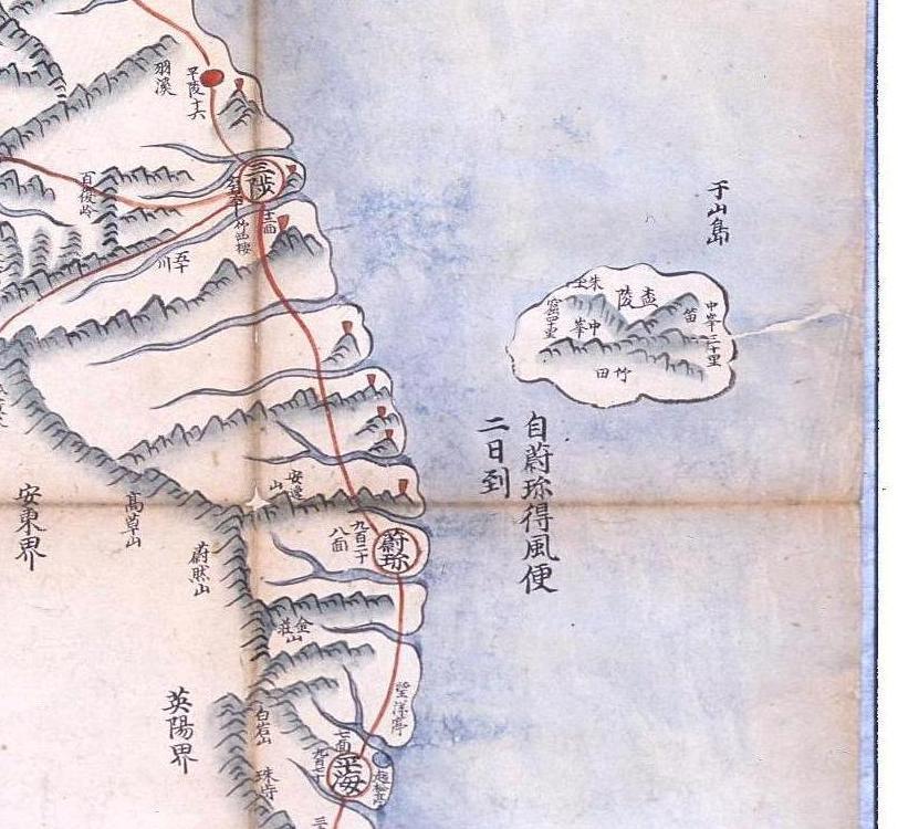
The following map was made in 1822 and is from an atlas entitled Jido (地圖). It is stored in National Library of Korea. The Gwandongdo (關東圖) map shows Usando (于山島) just off the northeast shore of Ulleungdo. Usando was the old name for Ulleungdo's neighboring island of Jukdo (竹島), which is just two kilometers off the northern half of Ulleungdo's east shore.


By the way today's Manyangjong望洋亭 ,about 3km south of Uljing, is new one after 1850's and
ReplyDeleteold Manyangjeong ,about 15km south of Uljing and 12km north of Pyonghae, is almost same place on this map.
Especially, many record of Manyangjong and Sogondae they explain Ulleungdo.
Samchok-Sogondae三陟召公台,about 30km south of Samchok and also 30km north of Uljin.
(not drawn on this map)
I saw Ulleungdo poem or writing on Manayngjeong望洋亭, Wolson-jeun越松亭, and Chukseokrou竹西楼.
By the way I did interview with locals each place and they said Ulluengdo can be seen from there only when weather is fine.
When I visit Sogondae I witnessed Ullengdo very slightly just 10seconds and it was disappear when I set Digital Camera and camcorder, even though it was fine day.
I also got to know there are paintings of Manyangjeong and Ulleungdo by 金尚星 during 英祖 era.
This is stored by Kyuujanggak.(the photo at Samchok museum)
http://www.panoramio.com/photo/26081572
From 1870s, Korean somehow started losing Usando=Jukdo and stick to one island two names theory. This is one of the map which shows this. But around 1890s, they again recognized Usando as the biggest neighboring island of Ulleungdo. Weird.
ReplyDeleteGTOMR,
I thing that is critical information. You should make report about it. BTE, did you see Ulleungdo from the level ground/coast ?
And all the 三陟召公台, 望洋亭 or 越松亭 you mentioned are high place, aren't they? How high?
Im not sure the correct altitude because my alti-meter had already broken on Kenya.
ReplyDeleteNow Chukseourou三陟竹西楼, it is not visible from there because there are many building between Jukseourou and beach. But old times The East Coast is visible from Jukseourou竹西楼. I saw some description plate that they start from Jukseourou to inspection on Ulluengdo (Im not sure when it was described.)
I remember I read some book that Samchok-Sogondae(三陟召公臺 is 300m above the sea level.
New ManyangJeong望洋亭 is just a 100-150m but locals said possible to see Ullengdo.(I didnt see it )
Also they have some description about Ullengdo inside the pavillion.(Maybe 李山海 望洋亭記? on the link above.)
Also original Mangyangjeong望洋亭 is just a 15-20m above the sea level but locals said possible to see Ulleungdo. (I didnt see it )
From Pyonghae Wolsong-jeung平海越松亭 is just a 5-10m in front of the beach but locals said they never heard to see Ulluengdo from Wolsong-Jung. But possible to see it in the high place around Pyonghae.(I didnt see it )
Also they have some description about Ullengdo inside the pavillion.
From Yonghae Chuksan寧海丑山 the place is military base so I couldnt try it.maybe it is 100meter above the sea level.
I guess, good place to observe Ulleungdo is, between Sogondae and old Mangyangjeong because many peaks nearby The East Coast.
Locals said Ulluengdo is visible when it is perfect fine weather. I visit each place each two times but only one time witness so slightly at Sogondae.
To take photo of Ulluengdo need Compass, altimeter, and camera's lenz filter. also need car to visit Sogondae and Old Mangyangjeong.
It is very difficult to find Ulleungdo without compass and need calculation and check direction (degree) in advance which direction is collect of Ulleungdo (e.g. 89degree and so on).
When We drove on The East Coast road I couldn't feel the existence of Ulleungdo actually.
I couldn't see Takeshima Liancourt Rocks from Ullengdo.
From Seokbo observatory three times, Nausejeong observatory one time, and Songinbong two time.
In the description of Ulleungdo on the map, it gives its dimensions as follows:
ReplyDelete長百餘里廣六十里
Is 長 supposed to represent the east-west distance or the north-south distance?
I wonder why most old maps of Ulleungdo in the 1800s showed its east-west distance to be much larger than its north-south distance when they are both about the same? Old descriptions of Ulleungdo said it had an area (地方) of 100 ri. Is it possible that mapmakers confused the old area of Ulleungdo for its 長?
Thanks, GTOMR
ReplyDeleteGerry,
I thought 長百餘 is supposed to represent circumference.
Kaneganese,
ReplyDeleteIf 長 is the circumference, then there should be two more numbers for the east-west and north-south measurements, but there is only one. Therefore, on this map, I think 長 is supposed to be either the north-south or east-west measurement.
Since Ulleungdo is drawn horizontally longer, I would guess that 長 was supposed to be the east-west measurement on this map.
Of course, a lot of Korea's maps of Ulleungdo ignore the written description of the island. For example, there are several maps that say Usando (于山島) was east of Samcheok while also saying that Ulleungdo was east of Pyeonghae. Since Samcheok is north of Pyeonghae, that would put Usando north of Ulleungdo. Yet, some of the maps with that description show Usando either south or east of Ulleungdo. That suggests the mapmaker made the map without paying much attention to the written description. This 1822 map is an example of that.
For another example of what I mean, compare the written description of Ulleungdo and Usando with the actual drawing of Usando on the following map.
Samcheok and Ulleungdo - 1884 to 1994
The description said Usando (于山島) was east of Samcheok (三陟) while also saying that Ulleungdo was east of Pyeonghae (平海), which is south of Samcheok. The map of Ulleungo, however, shows Usando just off Ulleungdo's east shore, not north of Ulleungdo.
The written descriptions of Ulleungdo in the 1800s probably caused many Koreans to believe that Usando was somewhere north of Ulleungdo, rather than just two kilometers off Ulleungdo's east shore.
Is it possible that 長 represent the sum of the east-west and north-south measurements? I'm not sure, but the geographer/author should give you the whole measurement of the island first, then the detail next. Besides, the Chinese letter "廣" fits for width, not north-south measurements on the map. Having said that, I'm not perfectly sure about this issue. Those are just my thoughts.
ReplyDeleteGerry,
ReplyDeleteThere are other maps which have same desctiptions. See GTOMR's site.
https://sites.google.com/site/takeshimaliancourt/Home/koreansrecognizationofullengdodistrict
And he agrees with you. 禹用鼎's 1899 report has the sentence "長可為七十里 廣可為四十里".
Thanks GTOMR & Kaneganese.
ReplyDeleteI think the old "area" (地方 ro 四方) of Ulleungdo, which was recorded as 100 ri, ended up being used for the east-west length of the island. That would help explain the shape of Ulleungdo on maps in the 1800s.
I also have a theory about why the northern rocks did not appear on many of the maps of Ulleungdo.
On Bak Seok-chang's (朴錫昌) 1711 map of Ulleungdo, he labeled the northern rocks as 石峯, which literally means "rock peak." Mapmakers probably read 石峯 and assumed they were prominent "rock peaks" on shore, rather than offshore.
On Bak's 1711 map, Usando (于山島) was the only object clearly labeled as an island (島). I think The five unlabeled "rocks" off Ulleungdo's southern and southeast shores were meant to represent shallow rock groupings offshore rather than "peaks" (峯), which is why they were not labeled as "peaks." Since the rocks off the southern shore were unlabeled, mapmakers seem to have assumed they were small islands.
Even if you look at the other inspectors' maps of Ulleungdo, none of them made it clear, through labels, that the northern rocks were offshore, so mapmakers probably just assumed they were referring to rocks on shore. The rest is history.