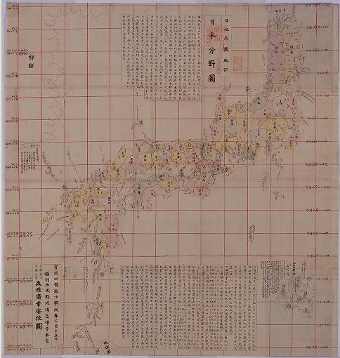
 (Left : "The Field Chart of Japan (日本分野図)" from the site of National Archives of Japan )
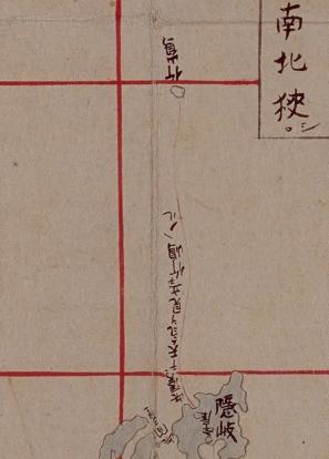 As we can see, "The Field Chart of Japan (日本分野図)" by Mori Kohan( 森幸安) clearly described Takeshima(Ulleungdo) as Japan's territory by drawing the sea route line from Oki to Ulleungdo. Nagakubo Sekisui is considered to have referred this map the most in the creating process of "Revised Complete Map of Japanese Lands and Roads", which Korean claim Nagakubo excluded Takeshima from Japan's territory, etc. In other word, against Korea's claim, this "The Field Chart of Japan (日本分野図)" by Mori Kohan( 森幸安) reinforces the Japan's claim that Nagakubo clearly recognized Takeshima and Matsushima as Japanese territory in 1779.
(Right : Closeup of "The Field Chart of Japan (日本分野図)" from the site of National Archives of Japan )
Nagakubo Sekisui(長久保赤水) depicted Takeshima as Japan's territory on his map of Japan.
A group of island that are currently called Takeshima were once known as "Matsushima," and the island that is now known as Utsuryo (pronounced Ulleung in Korean) used to be known as "Takeshima" or "Isotakeshima." Although there has been a period of temporary confusion concerning the names of Takeshima and Utsuryo Island due to an error in the charting of Utsuryo Island by European explorers and others, it is obvious from a variety of written documents that Japan has long recognized the existence of "Takeshima" and "Matsushima." For example, on many maps, including "Kaisei Nippon Yochi Rotei Zenzu (Revised Complete Map of Japanese Lands and Roads(日本輿地路程全図): first published in 1779)" by Sekisui Nagakubo, which is the most prominent published cartographic projection of Japan, the locations of Utsuryo Island and Takeshima are accurately recorded at their current position between the Korean Peninsula and the Oki Islands. (MOFA, 2008)
 Korean claims that the "Onshu-shicho-goki(隠州視聴合記)" and "the Complete Map of Japanese Lands and Roads", both of which Japan used as the basis to prove that Takeshima (Dokdo) was Japanese territory, instead are the basis to prove that Dokdo is Korean territory. The interpretation of the sentence “Viewing Koryo is just the same as viewing Onshu (Oki island) from Unshu (Izumo) [見高麗猶雲州望隠州]” makes it clear, however, to which of Japan or Korea the place where one could view Koryo belonged. Nagakubo Sekisui made that notation next to Ulleungdo when quoting from the Onshu-shicho-goki because he believed that Ulleungdo was Japanese territory--he wasn’t reconfirming that Dokdo was Korean territory.
Indeed, Saito Hosen, the author of Onshu-shicho-goki, also wrote in the book the fact that the Oya family from Yonago of the Tottori domain frequently visited Ulleungdo. He had no doubt that Ulleungdo was Japanese territory. And when one of the Oya family’s ships drifted ashore in Korea in 1666, one year before the publication of Onshu-shicho-gouki, the Korean government graciously returned it. The Edo Shogunate grasped the meaning of that event and also recognized that Ulleungdo was Japanese territory. Even in 1695, when Edo Shogunate banned Ohya and Murakawa clan the voyage to Ulleungdo, both government didn't even hinted Usando in the process of negotiacion, not to mention of Matushima, today's Takeshima/Liancourt Rocks, which suggests that Joseon didn't even know the existence of the tiny island 92km far from Ulleungdo. Ulleungdo had been the easternmost of Joseon territory, and none of Korean historical documents suggest Ulleungdo nor Usanguk, the old name of coutry of Ulleungdo, includes Takeshima/Dokdo. As we have seen, there is no evidence that Koreans ever traveled to Liancourt Rocks (Dokdo/Takeshima) before Japanese fishing boats started taking them there in the early 1900s, and the islets do not appear on any of Korea's old maps by any name.
Other concrete evidences that Nagakubo Sekisui considered Takeshima(Ulleungdo) and Matsushima as Japanese territory, most likely, the country of Oki.
-
 The additional remark next to Ulleungdo, "見高麗猶雲州望隠州( From there(Ulleungdo) you can view Korea, it is just like you view Onshu (Oki island) from Unshu (east of Shimane prefecture, mainland of Japan)", on his map was cited from the " Onshu Shicho Goki (隠州視聴合記)" by Saito Hosen, which states Ulleungdo was the westmost of Japanese territory.
 - He coloured both islands from the later edition as Japanese territory.
- In the first edition, not only two islands, but also other important Japanese islands like Gogohshima(御号島 : today's Okinoshima(沖ノ島), Kuchinoerabu(口永良部島)、Ezo(蝦夷地 : Hokkaido) were also uncoloured. It is obvious that those Japanese islands uncoloured were not considered to be outside of Japanese territory, but only described to be distant islands of Japan from the mainland.
- Nagakubo’s other map ("Map of Asia and Small Orient(亜細亜小東洋圖, 1835)") clearly shows Takeshima and Matsushima as Japanese territory.
- Nagakubo was in charge of compiling the geographical volume of the "Great Chronicles of Japan"(大日本史 or Dai-Nihonshi). The geographical documents were drafted by him. Under the article of 4 of district of Oki country, it says that "in addition, there are Matsushima(today's Takeshima/Liancourt Rocks) and Takeshima(Ulleundo) and those island belong to Oki.
 Mori Kohan (森 幸安 : 1701(14th year of Genroku) - ? )
Mori Kohan was born in Kyoto and studied the historical evidence for the map in the middle of Edo period. He collected or copied the maps of Japan and the world in Kyoto and Osaka from 1748 to 1763, counting almost 300 of them, and information related to the map was written down in detail on a margin by the Chinese writing . It is said that he combined those maps to produce "The Atlas of Japan (日本輿地図)". "The Field Chart of Japan (日本分野図)" of "The Atlas of Japan" described the parallel and the meridian for the first time as Japanese map and even latitude is recorded on the parallel line. Mori noted that he recorded the latitued to record the climate of each latitude (Japan is a warm coutny with the four seasons). Takeshima is also described as Japanese territory with sea route from Oki.
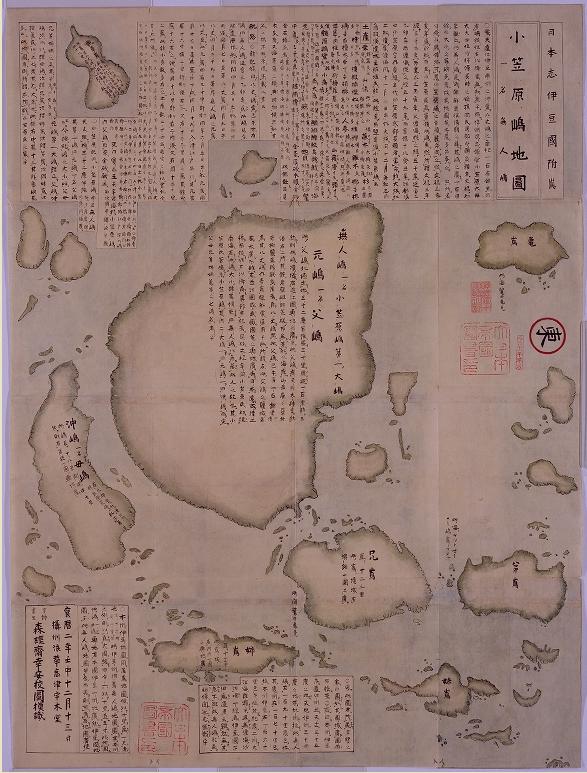
(Right : "The Map of Ogasawara islands (1752)" from "The Atlas of Japan" by Mori Kohan. It shows that Ogasawara Islands(Bonin Islands : 無人島) were well-recognized by Japanese as its territory way before American came around in 1800s.)
References :
Shimane Prefecture (Eng. Jap. & Kor.)
Japanese Ministry of Foreign Affairs (Eng.)
The 19th column “Seeking Truth Based Solely on Facts(実事求是)”
1696 - Ordinance Prohibiting Voyages to Takeshima (幕府 渡航禁制令)
1835 - "Map of Asia and Small Orient(亜細亜小東洋圖)" shows Takeshima/Dokdo as Japanese territory
1667 - Onshu Shicho Goki (隠州視聴合記)
1667 - "Onshu Shicho Goki(隠州視聴合記)" - The different translations
Kaneganese, as usual you are off the mark.
ReplyDeleteThis map shows us one thing for sure. The Japanese as a nation did not voyage to Dokdo island as a destination. They trespassed onto Korea’s Ulleungdo Island. This map has zero to do with Dokdo as the islets aren’t even to be found on the map.
Whatever the mapmaker had decided, it was clearly out of line with the Shogunate’s policy on Ulleungdo and thus has nothing to do with Japan’s real territory.
Don’t you know Kaneganese? The Shoguante officially “ceded” Ulleungdo to Chosun in 1695. Only a fool would state Japan’s Shogunate thought Ulleungdo was Japanese.
Kangegnese. How can you continue to lie to the public by publishing this rubbish? Shame on you!! Don’t you have any ethics at all?
I added the image of "The map of Ogasawara islands" and changed the English name of "日本輿地図" from "The map of Japan" to "The Atlas of Japan". Mori's "日本輿地図" consists of many maps, actually.
ReplyDeleteOh by the way, No More Multiple IDs / Sock Puppets, thanks.
ReplyDeleteAre Steve the frogmouth coming back with another name? Why can't you tell your opinion with the fixed ID? It may show your uncertainty in your opinion.
ReplyDeleteBTW, Liancourt Rocks were on the route to Ulleungdo, that's true. But it was from the viewpoint of Japan. On the other hand, Liancourt Rocks were beyond Ulleungdo, the eastern limit of Korea, to Korean side.
It was Ulleungdo that both of Korean and Japan argued about in the late 17th century, not Liancourt Rocks.
It is obvious that Liancourt Rocks didn't belong to Korea in the history.
Kaneganese,
ReplyDeleteThanks for the good job. Can you let us know the meaning of the sentence written upside down at the north of Oki island?
(・・・天気ヲ見立テ竹嶋・入ル???)
Thanks.
Pacifist, I didn’t change my ID somebody here or elsewhere highjacked it from me. Are you afraid of me posting the truth here? I find it hypocritical the Japanese lobbyists here are bothered by anonymous multiple handles when they themselves are afraid to post their own identities. In reality, I’m one of only two people on this whole forum whose identity is known (Steven Barber c/o dokdo-takeshima.com)
ReplyDeleteThen again, when I read the nonsense posted here, I can understand why Kaneganese and Pacifists would be embarrassed to reveal their real identities.
However, I digress. We should really stick with the subject at hand here instead of childish mudslinging
That being said, Kaneganese (whoever you are) How can you state Japan considered Takeshima (Ulleungdo) and Matsushima were Japanese territory after the year 1695 when Japan’s Official correspondence stated Ulleungdo was Korean land? Any record Japanese or otherwise post 1695 that states Ulleungdo was Japanese is simply inaccurate. Again, you should be very ashamed for misleading readers.
Kaneganese the link you gave us to Japan’s Digital Archives also had other maps of Japan. In fact the map right next to the one you provided clearly showed Japan DID NOT consider Ulleungdo and Dokdo as part of Japan. In fact, it excluded both islands and showed no voyage routes extending there. It was published at the same time as Mori Kohan's map (1754)
Please check the map below.
http://www.dokdo-takeshima.com/Nihon-tsushinzu-0.jpg
http://www.dokdo-takeshima.com/Nihon-tsushinzu-1.jpg
Also, you have to stop using the Saito Hosen’s report on Oki as evidence of Japanese sovereignty over Ulleungdo and Dokdo. The right wing Japanese interpretation of this record is wrong. The character “州” means “state” or “province” In other words, Saito Hosen acknowledged Oki Province as the northwestern limit of Japan.
Pacifist
ReplyDeleteThank you for your comment. I think the phrase starts with "此湊?ニテ". So it is saying that "from at this port( probably, Oki's Fukuura=福浦), they wait for a fair winds for sailing to Takeshima."
By the way Now I got to know 国立公文書館 website they add two interesting maps.
ReplyDelete1.1908. 韓国沿海水産物分布図 農商工部水産局
2.1912.朝鮮林野分布図 鬱陵島(宇佐国).
Kaneganeseさん、興味深い地図を紹介していただきありがとうございました。
ReplyDeleteGTOMRさん紹介のサイトを見ていましたら『天保国絵図』「隠岐国」
(http://jpimg.digital.archives.go.jp/jpg_prg/jgmWeb.dll?TmpFileDisp4?si=0&md=0&ql=10&env=jpeg2k_images/ezu/kuniezu_tenpo/089_oki.env&l=2&cy=7747&cx=7568&dy=600&dx=800&i=lossy/kouseisai/ezu/kuniezu_tenpo/089_oki.jp2&file=temp_kuniezu.html)という図を見つけました。
「天保6年(1835)その作成が命じられ、同保9年(1838年)に完成」と解説されていますから、竹島一件はもちろん竹島事件後に作成された官撰地図ということになります。これの隠岐国図の福浦のところに「●湊舩繋吉[竹嶋迄之渡海●湊ま● 天気見合る]」(●は読解できず)とあります。竹島松島の領有を直接裏付けるものとは言えないと思いますが、官撰地図にこのような記事が書き込まれることの意味はよく吟味されるべきと思います。
Matsu様
ReplyDelete確か正保日本図の隠岐にも天保日本図似たような記載(隠岐福浦に”竹島へ之渡海の船此港而天気見合申候)はありますが、なぜかとっておいた画像が出てきません・・・・
あと、この日本分野図の地図のデザインに近い西洋人(Kempfer?)の地図があったのですが、これもどこにあったのかが思い出せません。
また、1855.皇国総海岸圖 第四十八 隠岐島では、http://www.tanaka-kunitaka.net/senkaku/koukokusoukaiganzu-1855/05.jpg
隠岐の地図では、竹島渡海の港であった福浦(現在の隠岐の島町)付近に「松島竹島ハ亥子ノ間二当ル」が記載されています。
御号島の読みを”ごごうしま”に訂正しました。
ReplyDeleteMakotoさん
情報をありがとうございます。一見関係なさそうに思われても、後で重要な意味を持ってくることがありますので、気が付いた事をこちらにメモ代わりにコメントして下さい。ちなみに、日本分野図については下條先生の著書にこのように書かれています。(toronさんのサイトからコピペしました。)
”また、もう一つ重要な事実がある。
長久保赤水が日本輿地路程全図等の作成過程で最も参考にしたのは、森幸安の「日本分野図(1754年)」だと考えられている。
そして、この日本分野図には竹島(鬱陵島のこと)が描かれている。
しかも隠岐から鬱稜島までの航路入りである。
森はおそらく竹島を日本領として描いたのだろう。
(松島が載っているかどうかは未確認)。
長久保はこの「日本分野図」に「隠州視聴合記」の記述を加えて地図を作成した。
それは長久保赤水の「日本輿地路程全図」に描かれた鬱陵島(図では竹島と表記)の右上に「見高麗猶雲州望隠州(高麗を見る事、猶雲州より隠州を望むが如し)」という付記がある事からも解る。
この付記は齋藤豊仙の「隠州視聴合記」からの引用である。
隠州視聴合記は鬱陵島が日本領と考えられていた時代の記録である。
それから、竹島一件後も鬱陵島が依然として日本領であるという認識もあった。
この事実から見ても、長久保赤水が鬱陵島を日本領と認識していた事は明らかである。
崔書勉氏や堀和生氏は、「日本輿地路程全図」に付記した長久保赤水の見識を無視して、彩色の有無だけを問題にしていたのである。”(『竹島は日韓どちらのものか』下條正男)
1698年の幕府による竹島渡航禁止令では当時友好的な関係を保っていた朝鮮との領有権争いを避けて棚上げし、渡海を禁止しただけで、決して韓国側の言うように領有権を放棄したわけではありませんでした。その後、天保年間におこった竹島事件で、事実上放棄する(公式には明治に入ってから)わけですが、同時に「元々日本のものであった竹島は幕府の弱腰外交で朝鮮に与えてしまったが、松島(現在の竹島)は与えなかったので今だ日本のもの」という認識が民間に広まり、それが明治初年の度重なる松島(実は鬱陵島)開拓の建議につながるのだと思います。そして、それが『竹島考証』にあるようにさまざまな論議を呼び、外務省および海軍省を動かして、1880年の戦艦天城の測量を経て、1881年に"松島"は鬱陵島であり、"竹島"とは現在の竹島ではなく竹嶼であった(つまり竹島も松島も鬱陵島)、との結論に至ります。
国際法的な領有権議論はともかく、事実を拾い集めると、何故江戸時代を通して竹島(鬱陵島)が日本領であると考えられていたのか、また明治になってどのように変化したのか、がこのように理解されると思われます。
あくまで推測ですが、磯竹嶋略図のシリーズ以外で日本分野図以前、竹嶋(鬱陵島)が書かれている地図としては、
ReplyDelete16C末期(1580-1600?)浄得寺所蔵日本圖屏風
1719.Henri Chatelain: Carte du Japon
があります。16
世紀末期に既に屏風に書かれた日本図に磯竹が有ることを考えると、其の元本になった地図があってもおかしくは無いと思います。
つまり1580-1600年当たりにそのような地図が会ったのではないか?と推測しますが、もちろんそのような地図は現状は発見されていません。
(これ以外では中国本の系統である1562「籌海図編』 鄭若曽 1668.異称日本伝 松下見林などがありますが、なぜか隠岐の北東に竹嶋が書かれています)
GTOMR,
ReplyDeleteIn the map "Carte du Japon", there are two tiny rocks which resemble Liancourt Rocks. If they (French mapmaker) knew these two rocks before Liancourt Rocks were discovered by French, how could they get the information about these two tiny rocks? It's very interesting!
matsu様・皆様 変体仮名判読しました。正保国絵図と天保国絵図の竹島記述
ReplyDelete国絵図に竹島と松島が描かれていないと韓国側は主張しますが、そもそも国絵図というものは、近世日本がその税収を掌握するための、穀物生産量調査である、郷帳の附図なのですから、お米を収穫することのできない岩礁や無人島などは記載されていなくて当然なのです。
http://www.lib.shimane-u.ac.jp/0/collection/da/da.asp?mode=fpx&id=A0000042_05&rid=1
島根大学図書館デジタルアーカイブ (国立公文書館所蔵)
正保出雲隠岐国絵図:正保2年刊(1645)
正保国絵図 隠岐の福浦には、
「此湊舟懸吉 竹島渡海此湊ニて天氣見合候」
(この湊、ふなかけよし。竹島渡海このみなとにて、天気見合わせそうろう)
http://www.digital.archives.go.jp/gallery/view/detail/detailArchives/0000000232
国立公文書館デジタルアーカイブ
天保国絵図1835年 隠岐の福浦には
「此湊舩繋吉 竹嶋迄之渡海、此湊尓天天氣見合留」と書かれています。変体仮名を現代のひらがなに代えると以下のようになります。
「此湊舩繋吉。竹嶋迄之渡海、此湊にて天氣見合る」読み方は、(このみなと、船つぎよし。竹島までの渡海、この湊にて天気見あわせる。)となります。
なお元禄国絵図(1697年)の隠岐は明治六年に已に焼失してしまったか、現在見ることは出来ません。
小嶋様
ReplyDeleteおお、ありがとうございます。
国絵図の表記はとても重要ですね。
いま対馬の天保図をデジタルアーカイブで見ましたが、朝鮮への渡航ルートは、明確に「朝鮮」の文字がありますね。解読できませんが…他はどうでしょうか。
作成者が竹島への渡海を朝鮮、もしくは版図外の島へ渡航するものだと認識していたとは到底言えないと思います。
天保国絵図(1835~1838年) 対馬国の北側にある朱書き航路脇の記載は
ReplyDelete「佐須奈浦ゟ朝鮮和舘迠四拾八里」(佐須奈浦より朝鮮和館迄四拾八里)ですね。
国立公文書館デジタルアーカイブ
http://www.digital.archives.go.jp/gallery/view/detail/detailArchives/0000000252
日本分野図 森幸安作成 宝暦4年(1754)書写 国立公文書館所蔵
ReplyDeletehttp://www.digital.archives.go.jp/gallery/view/detail/detailArchives/0000000305
対馬の鰐浦
「此ノ鰐ノ浦ヨリ朝鮮ノ釜山浦ヘ二十五里」(朱書航路の先に) 「釜山浦」フサンホの振り仮名)
隠岐の福浦
「此湊ニテ天気ヲ見立テ竹嶋ヘノル」(朱書航路の先に) 島が一つ描かれていて「竹嶌」と記述されている。松島は描かれていない。
朝鮮領の釜山浦には、フサンホと仮名が振られているのに対して、現在の鬱陵島は、朱書きで航路が引かれ、竹島と名が記されているので日本領土の認識。
-----------------------------------
隠岐福浦の年代順竹島註記をまとめて措きます。
正保国絵図 正保二年(1645) 出雲隠岐国絵図
隠岐の福浦に
「此湊舟懸吉 竹島渡海此湊ニ而天氣見合候」
(この湊舟がかりよし。竹島渡海、この湊にて天気見合わせそうろう)
http://www.lib.shimane-u.ac.jp/0/collection/da/da.asp?mode=fpx&id=A0000042_05&rid=1
http://dokdo-or-takeshima.blogspot.jp/2009/07/1754-field-chart-of-japan-map-of-japan.html
隠岐出雲両国図 17世紀中頃 国立公文書館所蔵
(正保国絵図の写し。失われた正保郷帳の村高記載)
http://www.lib.shimane-u.ac.jp/0/collection/da/da.asp?mode=fpx&id=A0000042_04&rid=1
「此溙舩掛リ吉 竹嶋へ之渡海之舩 此溙ニ而 天氣見合申候」 (この湊船がかりよし 竹嶋への渡海の船 此湊にて 天気見合わせ申しそうろう)
山陰道隠岐之図 鳥取県立図書館所蔵の隠岐絵図 判読不能。
http://www.library.pref.tottori.jp/kyodo/2006/img/016.jpg
元禄国絵図 元禄十年(1697)は 逸失
元禄隠岐国絵図の竹島記述に近いと思われるもの。
http://www.lib.shimane-u.ac.jp/0/collection/da/da.asp?mode=fpx&id=00288787a&rid=1#
隠岐国絵図 18世紀初頭頃か 島根大学所蔵
「此湊舟掛吉 竹嶋江之渡海 此湊ニ而順待」
(此湊舟掛吉 竹嶋えの渡海 此湊にて順待) 順待は、天候不順を避け順風を待つの意か
隠岐国絵図 江戸時代中期頃か? 岡山大学池田家文庫絵図 判読不能
http://ousar.lib.okayama-u.ac.jp/ikedake/ezu/detail/8620110926212618
日本分野図 宝暦四年(1754) 森幸安 作成
「此湊ニテ天気ヲ見立テ竹嶋ヘノル」
隠岐が書かれた「朝鮮八道総図」 河村克典氏による
「此湊ヨリ天気定竹嶌エ乗ル 凡百五十里余有之ト云」
http://www.pref.shimane.lg.jp/soumu/web-takeshima/takeshima08/2007/record200904.html
隠岐国絵図 文政九年(1826)(島根県立図書館所蔵)
http://www.pref.shimane.lg.jp/soumu/web-takeshima/takeshima03/takeshima_top07.html
http://www.pref.shimane.lg.jp/soumu/web-takeshima/takeshima03/takeshima_top08.html
「此湊船懸吉 竹嶋江之渡海 此湊ニ而 天氣見合ル」
(此湊船懸吉 竹嶋えの渡海 此湊にて 天氣見合る)
天保国絵図 天保九年(1838)
隠岐国の福浦に
「此湊舩繋吉 竹嶋迄之渡海、此湊にて天氣見合る」
http://www.digital.archives.go.jp/gallery/view/detail/detailArchives/0000000232
対馬国にある朱書き航路脇の記載は
「佐須奈浦より朝鮮和舘迄四拾八里」
http://www.digital.archives.go.jp/gallery/view/detail/detailArchives/0000000252
皇国総海岸図 安政二年(1855) 酒井喜熈
「松島竹島ハ、亥子ノ間ニ當ル」
「福浦湊。西請。入口廣三町半程。奥入一里半。湊入口深七八尋。
湊内深三尋。舩繋善。此湊ヨリ竹島ニ乘ル。」
http://www.tanaka-kunitaka.net/senkaku/koukokusoukaiganzu-1855/05.jpg
大日本籌海全図 明治元年(1868) 変更箇所(善→吉、ニ→エ)
「松島竹島ハ、亥子ノ間ニ當ル。」
「福浦湊 西請 入口廣三町半程。奥入一里半。湊入口深七八尋。
湊内深三尋。舩繋吉。此湊ヨリ竹島エ乘ル。」
http://archive.wul.waseda.ac.jp/kosho/ru11/ru11_00023/ru11_00023_0003/ru11_00023_0003_p0004.jpg
対馬鰐浦の項に
「此浦湊ヨリ朝鮮国釜山浦エ戌亥ニ向テ走ル。四十八里ト云。近シ」
http://archive.wul.waseda.ac.jp/kosho/ru11/ru11_00023/ru11_00023_0001/ru11_00023_0001_p0032.jpg
皆様、特報です。鳥取県立図書館郷土資料課の中村愛さまから調査報告を戴きました。
ReplyDeleteこれは、同図書館館所蔵の江戸時代の絵図「山陰道隠岐之図 157.0×95.1(cm)」に関する、小嶋日向守個人の調査依頼に対する回答です。
-------------------------------------------------------------
このたびは鳥取県立図書館をご利用くださいまして、ありがとうございます。
お問い合わせいただきました「隠岐絵図の記述」について回答いたします。
当館に所蔵しております『山陰道隠岐之図』の「福浦」の箇所をデジタル画像で確認しましたところ、以下のような記述を見ることが出来ました。
此溙ヨリ辰巳之風ニテ亥之方ヨリ戌ノ方エ掛テ走ル
竹嶋エ百里松嶋エ七拾里朝鮮エ百四十里此ケンニテ走ハ
不遠上々之湊家有リ
こちらの漢字読み間違いがいくつかあるかも知れませんが、
「竹嶋」の表記は確実にございました。
鳥取県立図書館郷土資料課 中村 愛
-------------------------------------------------------------
なお、私からの問い合わせの文面は、以下のようなものでした。
私は、現在国際問題となっている竹島のことを調査している「小嶋日向守」というものです。インターネットで、貴図書館所蔵の「山陰道隠岐之図 157.0×95.1(cm)」という江戸時代の絵図が有ることを知りました。しかし、都内在住のため、鳥取県立図書館郷土資料室に、デジタル画像を見に行くのは容易なことではありません。そこで、電子メールで内容をお尋ねすることにしました。
韓国は、江戸幕府の公式地図であった、「元禄國絵図」などの國絵図に竹島が描かれていないとして日本の竹島領有の不当性を主張しています。しかし、もともと国絵図とは、郷帳という諸国の全村落の石高調査の付属地図ですから、穀物生産のない離島や、無人の岩礁などは記載される筈がないのです。それを知った上で、日本側が反論しようのない地図を証拠に理不尽な言い掛かりをつけていると言えましょう。
ところがです。貴図書館所蔵の隠岐の絵図にその「あるはずがない」はずの竹島日本領有の証拠が記載されていると私は考えているのです。それは、地図に竹島自体は描かれていなくても文字で記載されているということで、要点は、その絵図の隠岐の島後にある福浦という西側の港に記載されている一文の内容を御教示願いたいという一点だけです。
直接、貴図書館に訪問せずに、そちらの司書さまに調査をお願いするのは心苦しいのですが、事実を明らかにすることは、日本の国益のみならず、韓国との真の友好にも寄与することと思いますので、なにとぞ、よろしくお願い申し上げます。
といった内容でした。
http://www.library.pref.tottori.jp/kyodo/2006/img/016.jpg
低解像度の画像しかありませんが、福浦のところに、三行、計60文字弱の書き込みがあることが朧気ながらわかります。竹島だけでなく松島の文字もあったことも貴重だと思います。
小嶋さん
ReplyDelete確かに特報ですね!
大ヒットだと思います。
福浦を縦軸(時間軸)でさぐって行く、というのは、竹島問題を考えるときの重要なポイントだと思います。
明治~昭和にも、もしかしたらこういう記録が出てくるのではないでしょうか。
過日、鳥取県立図書館郷土資料課の中村 愛さまから続報メールを戴いていました。
ReplyDelete小嶋日向守個人宛のものですが、いろいろ憂慮すべき現状を感じますし、公開史料に関することでありますので、遅ればせながら、皆様に報告いたします。
なお、鳥取県と言えば、旧鳥取藩士であった戸田敬義が、「島根県士族」と署名していたことでも知られるように、現在の鳥取県も島根県と呼ばれた時代があったことや、鳥取県立博物館に戸田敬義家の記録が所蔵されていることなど、竹島・松島関係の史料がこのほかにもたくさんあるのですが…
------------------------------------------------------------------
小嶋日向守 様
お問い合わせいただきありがとうございます。
現在の「竹島」と絵図の「竹嶋」が異なるものであることを存じ上げず、失礼しました。
さて、まず『山陰道隠岐之図』の年代についてですが、
データを調べてみたものの、今のところ絵図の年代が特定できる資料が見つかっていません。
もし今後何らかの情報が得られましたら、そのときは連絡いたします。
そして、高解像度の絵図の公開をという要望をいただきましたが、
現時点で館外からのアクセスを実現するのは難しいと思われます。
というのは、一つはこの絵図は当館所蔵のものですが、「隠岐」は地理的には島根県の所属であり、
厳密な意味での”郷土資料=鳥取県に関する資料”から外れてしまうからです。
もう一つは予算の関係ということで、今後も高解像度化の見通しは立っていません。
また、仮に予算が組めたとしても、先ほどの理由も含めると
おそらく”鳥取という地域を表した絵図”から処理をしていくでしょうから、
隠岐之図を含む『諸国国絵図』の優先順位は低くなるだろうと思われます。
ですから、現時点で高解像度の絵図をご覧いただくためには、
「当館に直接ご来館いただき、専用の端末でアクセスする」ほかにはない状況です。
お力になれず申し訳ありませんが、ご理解いただきたく思います。
また何かございましたら、ご連絡ください。
***************
鳥取県立図書館 郷土資料課
中村 愛
〒680-0017鳥取市尚徳町101
電話番号0857-26-8155
ファクシミリ 0857-22-2996
***************
私から中村愛さまへのメールは、以下のようでした。
ReplyDelete--------------------
鳥取県立図書館 中村 愛 様
早速、お答え頂きましてありがとうございます。
絵図に書かれている「竹嶋」は現在の鬱陵島のことで、「松島」の方が、現在の竹島を意味していますが、松島の名称まで言及されている隠岐絵図は大変貴重なものと思います。
近いうちに、中村愛様の調査成果を、インターネット上の以下のサイトで発表させて戴く所存です。
http://dokdo-or-takeshima.blogspot.jp/2008/05/1894-jissoku-chosen-zenzu-by-so-mokan.html
http://dokdo-or-takeshima.blogspot.jp/2009/07/1754-field-chart-of-japan-map-of-japan.html
ただ問題は絵図の年代が不明ということです。私は比較的早い時代のものと考えていますが、それについて何か情報があれば御教示願います。
また出来れば、この隠岐絵図の高解像度の写真を是非公開して戴けるよう要望致します。
紹介したサイトに例示されている地図の所蔵図書館のほとんどが、高解像度の写真も公開しているだけに、残念でなりません。
小嶋日向守
Kaneganese,
ReplyDeleteYou wrote :
"As we can see, "The Field Chart of Japan (日本分野図)" by Mori Kohan( 森幸安) clearly described Takeshima(Ulleungdo) as Japan's territory by drawing the sea route line from Oki to Ulleungdo."
I have questions for you.
1. Why does sea route line relate to territorial definition? Can you explain it?
2. We all judge where the land is belonging to by the color. Mainland Japan and Oki Island are colored. However, Ulleongdo is uncolored same as mainland Korea. Doesn’t this mean Mori Kohan depicted Ulleongdo as Korean land?
You can view the enlarged cutouts here
3. What do you think about no Matsushim(Dokdo) in this map? No Dokdo means Mori Kohan didn’t consider Dokdo was Japanese land, right? Because there’s no reason not to draw Dokdo if he considered Dokdo as Japanese land.
4. You know exactly the Shogunate officially concluded Ulleongdo was Korean land. Then, don’t you think he was wrong if he considered Ulleongdo as Japanese land as you wrote?