正祖実録 正祖18年6月3日条
江原道觀察使沈晋賢狀啓言:
...二十六日轉向 可支島 , 四五箇可支魚, 驚駭躍出, 形若水牛。 砲手齊放, 捉得二首, 而 丘尾津 山形, 最爲奇異, 入谷數里, 則昔日人家遺址, 宛然尙存。
----------------------------------------------
Gangwondo Governor Sim jin-hyeon reported to the king.
“...We slept there and on the 26th, we changed direction (reversed course) and went to Gajido (可支島), where we surprised four or five sea lions that dashed out. They looked like water cows. Our riflemen all fired at once and got two of them. The geographical features of the beach landing (丘尾津) was the strangest thing. We went about ten ri into the valley, where we found the remains of what were clearly ancient dwellings. On both sides, the hills and ravines were so deep that they were difficult to climb up."
Actually, there are many documents which backs up this fact. For example, Japanese Ohya clan and Murakawa clan in 1600s frequently voyaged to both Ulldungdo and Takeshima/Dokdo and they were hunting sealions on both. (ex. "竹嶋之書附 ","小谷伊兵衛ニ所持被成候竹嶋之絵図之写:享保9年(1724)") Korean old maps also frequently list the skins of sealions(可支魚皮) as a products of Ulleungdo(ex. "Haedong Jido" (海東地圖) ). There are more as listed below.
Many Korean documents prove that there were Sealions living on Ulleungdo.
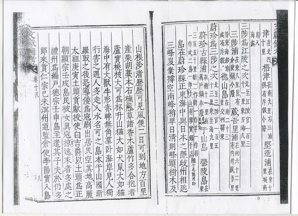 Dongguk Munheon Bigo(東國文獻備考 (1770)) stated that there were cows looking creatures lying on the beach of Ulleungdo("海中有大獣牛形赤眸無角群 臥海岸見人獨行害之遇人多走入水名可之").
1786 Inspection of Ulleungdo went to Gaji Beach (可支仇味) and found two caves of which some sea lions that dashed out.
We advanced to Gaji-gumi (可支仇味- Sea Lion Cove), where we found two caves in the side of the mountain.It was difficult to calculate their depth. We surprised some sea lions
that dashed out (of the caves), but before they could get into the water, all our riflemen fired at once and got two of them.
--------------------------
前進可支仇味則山腰有兩石窟其深難測可支魚驚出投水之際砲手齊放捉得二首
1827 Inspection of Ulleungdo also said there were many sealions on Ulleungdo.(可支魚窟), where they surprised seven or eight sea lions. They shot and clubbed them and got two of them before they could jump into the sea.

又到可支魚窟則可支魚七八首驚人入海之際砲搏捉得二首
1831 Inspection of Ulleungdo also said that they saw almost 110 sealions on Ulleungdo.
They then headed to Hyeonseok-gumi (玄石龜尾 - "Black Rock Cove"), where they saw a herd of about 110 sea lions mooing like cows. They got two of them with guns and clubs.1882 Korean official map of Ulleungdo depicts a cave on the west side of the island called Gaji-gul (可支窟), which means “Seal Cave.”
------------------------
仍向玄石龜尾則可支魚百十爲群吼哮如牛或砲或棒捉得二首
1899 September edition of Korea’s Hwangseong Newpaper printed an article that talked about "Gaji(可支 = Sealions)" on Ulleungdo.
In the past , there were water animals that looked like cows without horns that were called “gaji” .
-------------------------------
古에牛形無角한 水獸가 有하니 名曰可之오
1794 - June 3 - Han Chang-guk (韓昌國) Inspects Ulleungdo (日省録)
Lies, Half-truths, and Dokdo Video, Part 2
Lies, Half-truths, and Dokdo Video, Part 3
Lies, Half-truths, and Dokdo Video, Part 4Lies, Half-truths, and Dokdo Video, Part 4 Supplement
Lies, Half-truths, and Dokdo Video, Maps 2
I know this is not a news to anyone except for Korean, but Ijust posted so that I can use this later.
ReplyDeleteIf anyone found any mistake, please let me know. Thanks.
Gerry has already introduced the whole text and translated into English, but I want to put the original document according to the time table.
ReplyDelete江原道觀察使、沈晋賢狀啓言:
鬱陵島搜討, 間二年, 使邊將、輪回擧行, 已有定式。
故、搜討官・越松萬戶・韓昌國 處, 發關分付矣。
該萬戶牒呈:
“四月二十一日, 幸得順風, 糧饌雜物分, 載四隻船, 與倭學李福祥及上下員役、格軍八十名,同日未時(午前10時), 到于大洋中,
則酉時(18時), 北風猝起, 雲霧四塞, 驟雨霹靂, 一時齊發, 四船各自分散, 莫知所向。 萬戶、收拾精神, 戎服禱海, 多散糧米, 以餽海神後, 使格軍輩, 擧火應之, 則二隻船擧火而應, 一隻船漠然無火矣。
二十二日、寅時(午前4時), 怒濤漸息, 只見遠海之中, 二隻船帆自南而來。 格軍輩擧手指東曰: ‘彼雲霧中隱隱如雲者, 疑是島中上峰也。’
萬戶、詳細遠望, 則果是島形也。 親自擊, 激勵格軍,
卽爲到泊、於島之西面黃土丘尾津。
登山看審, 則自谷至中峰三十餘里, 而山形重疊, 谷水成川, 其中有可作水田六十餘石下種之地。 谷則狹窄, 有瀑布, 而左爲黃土丘尾窟, 右爲屛風石。
其上又有香木亭, 故斫取香木, 而以間年斫取之故, 漸就稀少。
23日は?
二十四日、到桶丘尾津, 則谷形如桶, 前有一巖在海中, 與島相距可爲五十步, 而高近數十丈, 周回皆是絶壁。 谷口巖石層層, 僅僅攀登而見之, 則山高谷深, 樹木參天, 雜草茂密, 通涉無路。
二十五日、到長作地浦, 谷口果有竹田, 非但稀踈, 擧皆體小。 其中擇其稍大者斫取後,
仍向東南楮田洞, 則自洞口至中峰爲數十里許, 而洞裏廣闊基址, 顯有三處, 可作水田數十石下種之地。
前有三島, 在北曰防牌島, 在中曰竹島, 在東曰瓮島。 三島相距, 不過百餘步, 島之周回, 各爲數十把, 險巖嵂, 難以登覽, 仍爲止宿。
二十六日、轉向可支島, 四五箇可支魚, 驚駭躍出, 形若水牛。 砲手齊放, 捉得二首,
而、丘尾津山形, 最爲奇異, 入谷數里, 則昔日人家遺址, 宛然尙存。 左右山谷, 甚爲幽深, 難於登陟。
仍遍看、竹巖、帿布巖、孔巖、錐山等諸處, 行到桶丘尾, 禱山祭海, 待風留住。
蓋島周回, 摠爲論之, 則南北七八十里許, 東西五六十里許。
環海則皆是層巖絶壁, 四方山谷, 則間有昔日人居之土址, 而田土可墾處, 合爲數百石下種之地。
樹木則、香、栢、蘗、檜、桑、榛。雜草則、靑芹、葵、艾、苧、楮。 其餘、異樹奇草, 不知名, 難以盡記。
羽蟲則雁、鷹、鷗、鷺。 毛蟲則、貓、鼠。 海産則、藿、鰒而已。
三十日、發船,
初八日(5月8日)、還鎭。
島中所産、可支魚皮二令、篁竹三箇、紫檀香二吐莫、石間朱五升、圖形一本, 監封上使” 云。
幷上送于備邊司
・・・・・・・・・・・・・・・・・・・・・・・・・・・・・・・・・・・・・・・・・・・・
We again get the same figure of 南北七八十里許, 東西五六十里許 as 李奎遠 and 禹用鼎.
It was all the same territory of “鬱陵島”. That does not include Takeshima/Dokto which is 230里 off .
I am wondering where is 桶丘尾(26日)= 桶丘尾津(24日)
It was used as the base camp, when they returned from the island until they got the good wind on 30th.
Is it トングミ in southern side?
I am wondering if they did the counter-clock voyage.
sorry correction
ReplyDelete× 李奎遠
○ 各部請議書存案17
"We again get the same figure of 南北七八十里許, 東西五六十里許 as 李奎遠 and 禹用鼎. It was all the same territory of “鬱陵島”. That does not include Takeshima/Dokto which is 230里 off ."
ReplyDeleteExactly. And this 可支島 cannot be today's Takeshima Dokdo. It should be within 南北七八十里許, 東西五六十里許, or it doesn't make sence.
I think 桶丘尾津(24日) is today's 通九味 since they were heading from west to east on the southern shore. Though there is no rock there.
There's 桶仇味 on sothern shore on official inspector's map of Ulleungdo. This one also describe 桶亀尾 on southern shore.
桶丘尾(26日) should be somewehre around 待風所 on the west side of Ulleungdo. I'd say 玄圃 or 台霞洞.
They voyaged counter-clock-wise, as a whole. I think after shot sealions, they were wondering around east coast of Ulleungdo, checking inside of the valley on that day(26th). Later, it says "行到桶丘尾, 禱山祭海, 待風留住", so they must have spent a few days to do some praying or preparing for return to peninsula, waiting for a good wind.
By the way, you can read more documents which mentioned sealions on Ulleungdo here.
ReplyDeleteSealion lives not only Lianocurt Rocks but also Ulleungdo and wide area eastcoast of Korean peninsula.
Thank you Kaneganese,
ReplyDeleteActually I have not read Gerry’s comment you mentioned carefully yesterday.
Now I have learned very much.
BTW, the date of the document is 正祖18年6月3日, isn’t it?
Thanks, matsu
ReplyDeleteI corrected the mistake.
I do not remember seeing the 1724 Japanese map of Ulleungdo shown HERE. Is there a link to a larger version of the map?
ReplyDeleteAlso, I think it would be interesting to start looking more closely at the Japanese maps of Ulleungdo. There are a lot of interesting maps on the Takeshima Research site that I would like to learn more about. There are a lot of interesting islets and coves on those maps that I would like to study more closely.
Starting next week, I will have time to start looking at this stuff again. I want to start studying the geography of Ulleungdo more closely and would like to map out and create a detailed list of Korean and Japanese names for places on Ulleungdo. I hope we can work on the project, together.
Gerry,
ReplyDeleteI'm going to send you an e-mail later. Please check it.
The map is a cutout of "小谷伊兵衛ニ所持被成候竹嶋之絵図之写:享保9年(1724)". You can see whole map here. (You did notice that he put "sealions" as a marker, right?)
Ah... I found it.
ReplyDeleteThis is my rough translation of the explanation of the map by Asso.Prof. Funasugi. I haven't finished translating all of his report. This map is informative since it has many explanations in red. It is the copy of 1694 version.
"4. 「A Copy of Illustrative Map of Takeshima Posessed by Kotani Ihei(小谷伊兵衛ニ所持被成候竹嶋之絵図之写)」(1724). property of Yonago San-in Historical Museum.
This is previously owned by Mr. Sasaki Ken, a local history researcher of Yonago, Tottori Prefecture. It was discovered by the Takeshima Research Group first time. It is unknown that how this map came to or from where. It is considered to be made in Edo era from the quality of paper and the form of a character written on the map. The title of the map is at the edge. As it was already explained in the third map, Kotani Ihei was the house manager in Edo among Genroku period, and he submitted the map of No.3 to Bakuhu in 1696. According to the description of the map, this is supposed to be copied from the illustrative map of Takeshima owned by Kotani in April, 1724. On the day of 16th April 1724, Tottori clan submitted the documents of Takeshima to Bakuhu by their request. On that occasion, they also submitted the illustrative map of Takeshima with the documents. "Map of Takeshima"(Property no.8439, Tottori Mueseum) is a copy of the illustrative map which was submitted to Bakuhu. From the chronological consistancy, this map seems to be copied when it was submitted to Bakhu in 1724(享保9年). Dogo in Oki, Matsushima (present Takeshima/Dokdo), Isotakeshima (Ulleundo) and Koryo (高麗) are depicted in the map. The contents in the map is almost same as in "3. Map of Takeshima submitted by Kotani Ihei(1696)" except for Dozen in Oki, Shimane peninsula and the sealine of Iwami.
However, this map has annotation in red all over. The note says " The annotation on the cover paper over the original map are written in red on the same place on this map." The original which Kotani posessed has this "cover paper"and it seems that this is copied in red in 1724. There is no note of cover paper on the illusurative map posessed by Tottori Museum. The notable point of this map is this annotation. There are the description of the distance to and the shores of Takeshima(Ulleundo). The explanation of the island says that "Takshima was called as Isotakeshima before, but we both decided to call it as Takeshima. When I send documents to Shogunate in Edo, I write the island as Takeshima." In the map, it was labeled as "Isotakeshima", but the annotation says that we (probably Oya and Murakawa clan who were engaged in the Takeshima business) called it as Takeshima." According to the documents "Isotakeshima Jiryaku(磯竹島事略)" which is considered to be compiled by Bakuhu officials, Matsue Han(松江藩) answered as "Takeshima was called as Isotakeshima by the people in Unshu(雲州)" to the inquiry by Bakuhu in 1696. And "Oki Koki Shu(隠岐古記集)" explains about Takeshima(Ulleundo) as "In this country, it was traditionally called as Isotakeshima." From those facts, 1696 map was possibley made based on the hearings from the boatsmen in Izumo(出雲) and Oki, not by Hoki(伯耆).
The explanation for "Hamada Ura(浜田浦)"says that "there were a map which says they don't harvest abalones around 2-3 chou left and right from Hamada Ura. The man who questioned boatsmen says that it wasn't like that in old times. When we voyaged, the fishermen harvested abalones as soon as they got. The harvest of abalone is from the begining of March to the end of the month while it still cold. We collect them in the box(?). The yeilds of sealions oils are good from the middle of April to the middle of May, thus we exclusively hunt them. After that, it is not that cold anymore on both places, so we do some hunting before we leave Takeshima." From this explanation, it is understood that this notes were made based on the inquiry by the boatsmen Oya and Murakawa clan took to the island. According to Sugihara, the vice chairman of Takeshima Research Group, the crew of Oya's ship which drafted to Choson in June of 1666 were recorded in "the Chlonicle of Oya clan". Though they were not all of the members, but we can grasp the outline, The name of 10 crew, 4 from Hoki and 6 from Oki were recorded. Moreover, the actual condition of the fishery business on Takeshima were also recorded. They harvested abalones as soon as they reached to Takeshima from early March to the end of March. As for the sealion oils, hunting and harvesting oils of sealions are excercised from the middle of April to that of May since the contents of oils were rich around the period of the year. As for other shores lik, Osaka-ura, Kita-ura, Yanagi-ura and Hokkoku-ura, it were same. It is the first case that the actual condition of the fishery business were revealed such in detail. In this point of view, this map was very important.
There are notes on each shores other than Hamada-ura on Takeshima either. "
Thank you, Kaneganese. That is very interesting, especially the part about their hunting sea lions on Ulleungdo. Does the map actually say where the sea lions were hunted on Ulleungdo? Anyway, it is an interesting map.
ReplyDeleteThere are notes at the bottom in red. They are the lists of Takeshima shores. In the explanation for Hamada-ura(浜田浦), it says they hunted sealions for its rich oils from the middle of April to that of May since the contents of oils were rich around the period of the year. As for other shores like, Osaka(大坂)-ura, Kita(北)-ura, Yanagi(柳)-ura and Hokkoku(北国)-ura, it were same.
ReplyDeleteThere is another notes at the top. It is a list of Isotakeshima shores. It says that there were sealion hunting fields(Michi-ba : みち場) on Hamada-ura, Osaka-ura, Kita-ura, Yanagi-ura, Hokkoku-ura and Take(竹)-ura.