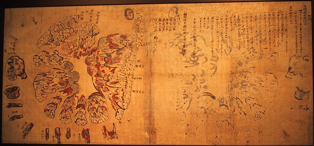
Below is an old Korean map of Ulleungdo called "Ulleungdo Dohyeong" (鬱陵島圖形). The exact date of the map is unknown, but it is believed to have been made sometime in the latter part of the Joseon Dynasty (1392 - 1910), before 1882. The map is the property of the
Samcheok Municipal Museum (三陟市立博物館).
Could we work on translating it together?

I imput the Chinese Charactor to make it clear on the Map.
ReplyDeleteSamchok museum Map of Ulluengdo
Nearby 沙汰仇味 there are a prominent rocks
Check 沙汰XX in the 1918 map.(southwest/nearby 南陽堂),considered to be 鳳巖
It seems doubt that this map is published on 1702.....
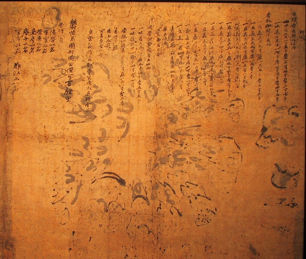
The text on the right side it seems small rock’s height and explanation? but I cannot read it clearly.
Then they wrote how many and who join the inspection.
Hi gtomr,
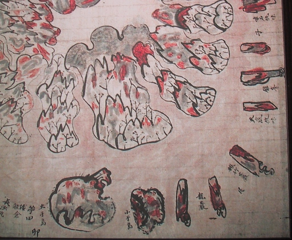
ReplyDeleteGood job, but I think the two islands are labeled 大于島 (Dae-Udo) and 小于島 (So-Udo), not 大干島 (Dae Gando) and 小干島 (So Gando).
Much of the writing on the right is strange to me, but it seems to be a list of products brought back, rather than a description of the land. The length (長) and width (廣) measurements could be describing trees and bamboo brought back. One product I do recognize it the ""five seung of ocher (朱土五升).
Also, besides the product list, it lists the members of the inspection party and gives the circumference of the island.
Anyway, there still seems to be a lot of mystery to this map. I still wonder who made it and when.
Thank you for the photo, Gerry.
ReplyDeleteAll I could read was as follows. I omitted many words from the list, since they looks like just a explanation of the product. And I put ● which I couldn't read.
I'll add more information later when I have more time.
封●(契?)
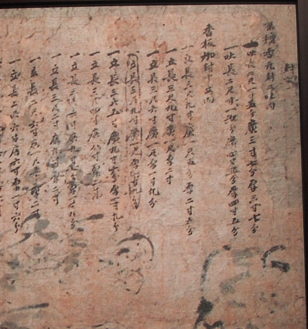
●壇香元封ニ吐内
一●(口:left 大:right)六尺一寸...
一●(口:left 大:right)長二尺寸...
香板加封立内
一立長六尺...
一立長三尺...
・
・
・
一立長ニ尺...
青竹三籠...
朱土六升
可支魚皮ニ令
巡営細紫壇香三吠内
一●(口:left 大:right)長二尺一寸廣五寸伍●厚五寸五分
一●(口:left 大:right)長六●一尺●四寸●四寸
香板一立●三尺八寸廣一尺一寸●二寸
●竹●●
朱土五升
可支魚皮小魚
京営●将●ニ歩量●造成具●金次
鬱陵島図形周回僅可百餘里
営将一●
倭学一名
軍官二名
営●一名
吏●一名
庫子一名
望年二名 吐堅一名
Hi Kaneganese,
ReplyDeleteUsing some of your characters, here is what it looks like to me:
封古
名*壇香元封ニ吐內
一吐 長六尺一寸五分 廣三寸七分 *三寸七分
一吐 長二尺寸一*分 廣四寸五分 *四寸五分
香板*封十立內
一立 長三尺九寸 廣一尺*分*二寸*分
一立 長三尺九寸 廣一尺*二寸
一立 長三尺六寸 廣一尺*一寸九分
(立 長三尺九寸 廣一尺*一寸九分)
一立 長三尺五寸 廣九寸六分*一寸九分
一立 長三尺四寸 廣八寸*二*
一立 長三尺三寸 廣九寸****分
一立 長三尺二寸 廣六寸*二寸
一立 長二尺六寸 廣一尺五寸*二寸
一立 長二尺六寸 廣六寸*一寸六分
一立 長二尺四寸 廣八寸*六寸
靑竹三籠...
朱土六升
..魚皮ニ*
巡*****二吐*
一吐 長二尺*寸 廣五寸五分*五寸
一吐 長六*一尺 廣四寸*四寸
香板一立*三尺八寸 廣一尺一寸*二寸
靑竹**
朱土五升
可支魚***
京***ニ部量*造成具*金*
鬱陵島圖形周回僅可百餘里
營將一
倭學一名
軍官二名
營吏一名
吏*一名
庫子一名
望牢二名 都*一名
If anyone finds any mistakes, please let us know.
I have added another image to the post that is a partial image of the text on the right. I added it because it is a little clearer and may help people recognize the Chinese characters.
ReplyDeleteAs Mr.Gerry refers, those are product list
ReplyDeleteSamchok map of of Ullunegdo Product List
There are hints those products on 1786~1831 inspector report
And the two map in samchok and korea central library matchs especially 1827 or 1831
1786
1794
1807
1827
1831
I wonder why no many inspection afater 1831 to 1882???And how Takeshima reserch center recognized the year of those maps.
厚=thickness
ReplyDeleteThank you, Anonymous. I was hoping someone would tell me what that character was.
ReplyDeleteDirect link to Samchok museum about this map
ReplyDeletehttp://www.scm.go.kr/bor/bor_data.jsp
(Choose no.41 울릉도 도형 )
direct link from Samchok museum map here;
http://www.scm.go.kr/downfile/dat/57/20080331113527000울릉도도형.jpg
Thanks, GTOMR.
ReplyDeleteThe Korean says the map is believed to have been made in the 19th century. It mentions that previous maps did not use the term 仇味 to refer to the coves on Ulleungdo. Another unique characteristic of the map is that it lists the products the inspector brought back to present to the government.
By the way, I think one of the reasons inspectors brought back a select number of products from the island was to prove that they had actually gone to the island.
Also, I have noticed on the two islands labeled 大于島 and 小于島 that the mapmaker tried to draw the caves that are on the back sides of Jukdo (竹島) and Gwaneumdo (觀音島). Jukdo has three or four cave-like hollows and Gwaneumdo has two caves on the sides facing away from the main island of Ulleungdo.
The following link is a picture that shows the backside of Jukdo:
Photo of Jukdo