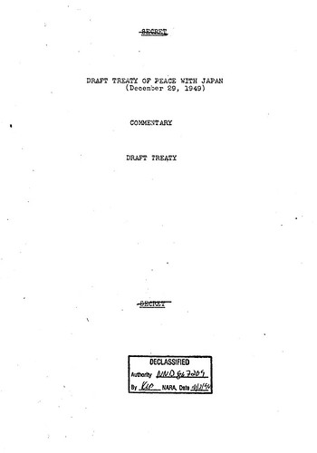
The artcle is quite perplexing since it is well-known that the Takeshima/Dokdo was listed as the territory held by Japan and remove the island from the Korean territory that it would renounce in the next draft made on 29th December, 1949, which was right after this draft of Peace Treaty made on Nov. 2, 1949. US decision that Takeshima remains as Japan's never changed in the final Treaty and Takeshima remained to be Japan's territory in the end.(Left: Prof. Jung Byung-joon(鄭秉峻) of Ewha Womans University , from Choson Ilbo)
A map used by the U.S. while drafting a peace treaty with Japan at the end of World War II clearly indicates that the Dokdo islets are Korean territory. The find adds to a growing body of evidence that Japanese territorial claims to islets are without merit.
Prof. Jung Byung-joon of Ewha Womans University discovered the map in the MacArthur Memorial Archives in Norfolk, Virginia in 2008 and included a copy in his book "Dokdo 1947." It was drawn up by the State Department on Nov. 2, 1949 and sent to Gen. Douglas MacArthur, then supreme commander of the Allied Forces headquartered in Tokyo, along with a draft peace treaty.
So it is quite natural that this Prof's "newly discovered" map, attached to the Draft, depicted Liancourt Rocks within Korean territory since that is what the draft on Nov. 2, 1949 said. The point is, this draft, text and map, were amended and replaced by next draft made on 29th December, 1949. Although the map attached to the 29th Dec. 1949 draft is yet to be found, Prof. Jung Byung-joon's claim "the November 1949 map depicting Dokdo as belonging to Korea was the final version" is not true. The map is not the "final version" nor it "confirm" Korean sovereignty since it was already replaced with next draft. It’s pointless to intimidate Japan not to claim territorial sovereignty over Takeshima with this map.U.S. Draft made on December 29, 1949
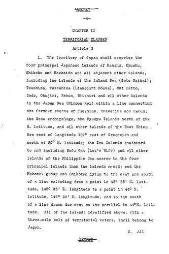
Article 3
1.The Territory of Japan shall comprise the four principal Japanese islands of Honshu, Kyushu, Shikoku and Hokkaido and all adjacent minor islands, including the islands of the Inland sea(seto Naikai); Tsushima,Takeshima (Liancourt Rocks), Oki retto, Sado, Okujiri, Rebun, Riishiri and all other islands in the Japan Sea (Nippon Kai) within a line connecting the farther shores of Tsushima, Takeshima and Rebun; the Goto archipelago, the Ryukyu Islands north of 29° N. Latitude, and all other islanls of the East China Sea east of longtude 127° east of Greenwich and north of 29°N. Latitude; the Izu Islands southward to end including Sofu Gan (lot's Wife) and all other islands of the Philippine Sea nearer to the four principal islands than the islands named; and the Habomai group and Shikotan lying to the east and south of a line extending from a point in 43°35' N.Latitude, 145°35' E. logitude to a point in 44°N. latitude, 146°30' E. longitude, and to the south of a line drawn due east on the parsllel in 44° N. Latitude. All of the islands identified above, with a three-mile belt of territorial waters, shall belong to Japan.
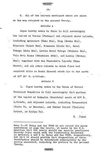
2. All of the islands mentioned above are shown on the map attached to the present Treaty.
In fact, Mr. Tsukamoto Takashi from the Japan’s National Diet Library had already wrote about this drafting process of Peace Treaty with Japan in his article written in 1994. He’s already introduced the Article 6, which deals with territorial issue, of this draft of Peace Treaty made on Nov. 2, 1949 and the article clearly stated that it has attached map.
The drafting process is well-written in English by Shimane’s Web Takeshima Research Center as below.
The principles of international law have great significanceOn January 18th 1952, the President of ROK Syngman Rhee (李承晩) suddenly issued a Declaration concerning maritime sovereignty, with which he installed the so-called “Syngman Rhee Line” including Takeshima/Liancourt Rocks in the Korean territory, it was three months before April when the Peace Treaty would be effective.
It is an established principle of international law that a peace treaty is the final determination of a country's territory, however. Whereas the Potsdam Declaration of July 26, 1945 stated, “Japanese sovereignty shall be limited to...such minor islands an we determine, ” SCAPIN #677 specified, “ Nothing in this directive shall be construed as an indication of Allied policy relating to the ultimate determination of the minor islands.” The Allies again declined to make a decision in SCAPIN #1033, which stated, “The present authorization is not an expression of Allied policy relative to ultimate determination of national jurisdiction, international boundaries or fishing rights...”
The peace treaty is therefore the key to the puzzle, but how does it deal with Takeshima? A draft of the peace treaty with Japan formulated in March 1947 defined the extent of Japanese sovereignty, which included the main islands of Honshu, Kyushu, Shikoku, and Hokkaido, as well as such outlying islands as Oki, Sado,and Tsushima. On the other hand, its provisions stated that Japan renounced the rights and title to the islands of Cheju, Komun, Ulleungdo, and Takeshima. This principle remained unchanged until the draft of November 1949.
A Change in the Provisions Concerning Takeshima at the Draft Stage
The situation began to change when the acting Political Advisor in Japan, William J. Sebald, went a note to the U.S. State Department stating, “Recommend reconsideration Liancourt Rocks (Takeshima), Japan's claim to these islands is old and appears valid” As a result, the treaty draft was amended in December 1949 to add Takeshima to the territory held by Japan and remove the island from the Korean territory that it would renounce.
The later American discussions with the British subsequently adhered to this policy, and the joint American and British draft of June 14, 1951, stated that the territory Japan would renounce would be Cheju, Komundo, and Ulleungdo. This clause eventually became Article 2 (a) of the San Francisco Peace Treaty. The treaty was signed on September 8, and all that awaited was its enforcement on April 28, 1952.
In response to this, the South Korean government that had taken office on August 15, 1948, demanded the revision of the Revised American and British Draft Treaty on July 19, 1951, to include both the islands of Dokdo (Takeshima) and Parangdo (a submerged island) as part of its territory. The American government rejected this demand for revision, however, stating, “Takeshima was...never treated as part of Korea and, since about 1905, has been under the jurisdiction of the Oki Islands Branch Office of Shimane Prefecture of Japan. The island does not appear ever before to have been claimed by Korea.”.
1952- January: Syngman Rhee Line
Later, on 12th July, 1954, Korean invaded Takeshima with heavily armed forces and refuse to bring the issue to ICJ against Japan’s proposal.
The Choson Ilbo’s strange discovery story continues as follows.
Jung also discovered another U.S. government map, equally putting Dokdo in Korean territory, that was drawn up by a policy planning taskforce of the State Department on Oct. 14, 1947 to define Japanese territory. Until recently it was believed that this map was drawn up in 1949 or 1950.
The map he “discovered” is the map made by Jorge F. Kennan, the director of the Policy Planning Staff(PPS). The documents are included in the FRUS, The Foreign Relations of the United States, a book series published by the Office of the Historian in the United States Department of State. It’s even available online here. Moreover, the PPS documents are sold in the form of microfilms more than 20 years ago. How on the earth he can “discover” the map which is open to the public ages ago?I strongly recommend Prof. Jung and Choson Ilbo to stop this kind of silly argument and claiming that he “discovered” things which are already known.
The initial information of the Choson Ilbo’s article was informed by matsu and other information concerning to the drafting process of the Peace Treaty were provided by Mr. Tsukamoto.
Mr. Tsukamoto Takashi's article is written in Japanese.
Takashi Tsukamoto, "Heiwajoyaku to Takeshima (sairon)" Reference 1994. 3, pp. 31-56. (塚本 孝「平和条約と竹島(再論)」、『レファレンス』第518号、国立国会図書館調査及び立法考査局、1994年3月、pp.31-56)
The article and related articles in Japanese.
独島:「韓国領」明示1949年の米国の地図を発見 (cache)
独島:鄭秉峻教授「1947年が重要な分岐点」 (cache)
独島:初めて領土標識を立てた「独島学術調査隊」 (cache)
References ;
History of San Francisco Peace Treaty
1946 - SCAPIN 677 - #1
1946 - SCAPIN 1033 - #2
1947 - SCAPIN 1778 - #3
1949 - Willam J. Sebald's telegram - #4
1949 - A letter from W. Walton Butterworth - #5
1949 - December 29th; 6th Amendment of the Treaty Draft - #6
1950 - July - Commentary on Draft Treaty by the Department of State - #6-b
1950 - August - U.S. Draft of the Peace Treaty - #6-c
1950 - October 26th - USA Answers to Questions Submitted by the Australian Government - #7
1951 - April - May: Joint UK and USA Draft - extra(1)
1951 - June 1 - New Zealand's view - extra(2)
1951 - July 9th - Coversation of Yu Chan Yang with John F. Dulles - #8
1951 - July 19th - The 2nd Conversation between Yu Chan Yang and John F. Dulles - #9
1951 - August - Another letter from You Chan Yang - #10
1951 - August 3rd - Memorandum - #11(On re-ceiving Boggs's memo. I asked the Korean desk to find out whether anyone in the Korean Embassy officer had told him they believed Dokdo was near Ullengdo, or Takeshima Rock, and suspected that Parangdo was too.)
1951 - August - Rusk's Letter - #12
1951 - September 9th - San Francisco Peace Treaty - #13
Korea's Illegal Land Grab from Japan
1952- January: Syngman Rhee Line
After the Installation of Syngman Rhee Line - American documents
1952 - November - Confidential Security Information of USA - #1 ("It appears that the Department has taken the position that these rocks belong to Japan and has so informed the Korean Ambassador in Washington." )
1952 - December - Confidential Security Information of USA - #2( "I much appreciate your letter of November 14 in regard to the status of the Dokdo Island (Liancourt Rocks). The information you gave us had never been previously available to the Embassy. We had never heard of Deen Rusk’s letter to the Korean Ambassador in which the Department took a definite stand on this question.")
1953 July: Confidential Security Information of USA - #3( The United States Government's understanding of the territorial status of this island was stated in assistant Secretary dated August 10,1951.")
1953 - November - Secret Security Information of USA - #4 ("The Liancourt Rocks case appears to have aspects in common with that of Shikotan Island" "Remind the ROK of our previous statement of view (the Rusk letter)")
1953 - December - SECRET SECURITY INFORMATION by Dulles - #5


