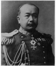
 Kimotsuki Kaneyuki, a director of Hydrography Department, and a mayor of Osaka, was born in Kagoshima(鹿児島) in1853. He is a nephew of Komatsu Tatewaki Kiyokado (小松 清廉(帯刀) ). The lieutenant of naval forces(海軍中尉), is known as the first Japanese who observed latitude by the Talcott Method, and obtained the value of 35 degrees 39 minutes 17 seconds 492 of north latitude in the Tokyo Azabu naval forces marine meteorological observatory in 1876. This was the first measurement of numerical value in the Japanese latitude and longitude datum point. He was the person who measures the latitude value of the Japanese latitude and longitude datum point, and executes a Japanese original domestic longitude telegraphic communication measurement for the first time.
Kimotsuki's previous name was Eda(江田), then Ohtomo(大伴), and his childfood name was Sentaro(船太郎). He served Hokkaido Development Commissioner(北海道開拓使) from 1869, surveyeing the land, then worked for the waterway division in 1872. He observed 19 pairs of the stars 109 times by the Talcott method with Dabittoson meridian transit instrument based on the Washington star table, and Astronomical latitude was decided by his effort in 1876. This is the "Kimotsuki Point" of naval forces marine meteorological observatory in Azabudai, Minato, Tokyo and the latitude values of the Japanese latitude and longitude starting point were made by shifting this value to the transit circle (子午環). Though he planned for the passing difference observation between Hokkaido and Tokyo in 1876, he had to change the plan to the measurement between Aomori of Tokyo due to the breakdown of the bottom of the sea electric wire. This is the first longitude telegraphic communication measurement in Japan.
Kimotsuki started from a clerical work at the marine meteorological observatory, then served as a subleader of the measurement section, later became the chief of land surveyrance section in 1883. He became the second and the forth director of the Hydrography Department and served for 16 years as a director, contributing the development of the waterway business enormously. After he had retired from the service, he became the member of the House of Peers(貴族院) in 1911 and the mayor of Osaka city in 1913.
The waterway division started by the Yanagi Narayoshi(柳楢悦), a father of Yanagi Muneyoshi (柳宗悦) who had devoted to the folk arts from Korean Lee Choson Dynasty, as a waterway inspector, one commander, and two majors or less in 1871. They executed the Hokkaido coast measurement at first in cooperation with the British warship Sylvia, and gradually built a system to be able to conduct waterway measurements by themselves. The first chart "Kamaishi(釜石)" was completed in September, 1872, and a real waterway measurement had thus begun.The division became independently to naval forces Hydrography Department in 1886, and afterwards, it became big organization of 105 people of the number of staff, and the Yanagi became the founder director of Hydrography Department and the Kimotsuki, a measurement section chief in the waterway divisionin 1887.
In 1880, Navy sent warship Amagi and found "Takeshima" which was questioned for its sovereignty by Japanese was Jukdo(Boussole Rock) and "Matsushima" was Ulleungdo. Today's Takeshima/Liancourt Rocks hadnever been a matter of territorial concern between two countries before 1906. When Nakai Yozaburo, a businessman from Oki came to him and sought an advise from him in 1904, he, as a director of the Hydrography Department who published 1894 "Choson Waterway Magazine" which clearly states that Korean eastern limit is 130°35′, said it should be Japan's. Since Kimotsuki was a specialist of surveyrance, it was natural for him to correct Nakai Yozaburo's misunderstandings that Liancourt Rocks "belonged" to Korea from "seacharts", which has nothing to do with territory claim and advise him that it should be Japanese territory since the sovereignty of Liancourt Rocks was indeterminate and it is nearer to Japanese main island than Korean peninsula.同島の所属は確乎たる徴証なく、ことに日韓両国よりの距離を測定すれば、日本の方十浬の近距離にあり(出雲国多古鼻より百〇八浬、朝鮮国リッドネル岬より百十八浬)加ふるに、朝鮮人にして従来同島経営に関する形迹なきに反し、本邦人にして既に同島経営に従事せるものある以上は、当然日本領土に編入すべきものなり(『竹島経営者中井養三郎氏立志伝』 (奥原碧雲, 1906) )
--------------------------------
There is no concrete evidence of sovereignty of the island. And especially measuring the distance from both Japan and Korea, it is closer to Japan by 10 nautical miles. (It is 108 seamiles from Takohana, Izumo country and 118 nautical miles from Lidnell cape of Korean peninsula. ) and as far as there are Japanese who are already engaging in managing the island while there is no trace of Koreans who managed the island, it is natural to incorporate it to Japan. ("The Manager of Takeshima; The Success Story of Mr. Nakai Yozaburo" by Okuhara Hekiun, 1906)
In spite of Korea's desperate pursuit for finding similarity between the 1905 Takeshima Incorporation by Japan and 1910 Japanese annexation of Korea, there is absolutely no evidence that those two incidents shared any direct connection. Incorporation of Takeshima into Shimane was nothing like a "stepstone" for the annexation, but simply a peaceful process which followed the international law.
Japanese government incorporated Takeshima, reconfirming/replacing its historic title with modern title in 1905 and Korean Imperial government officially acquiesced the Japan's sovereignty over Takeshima/Dokdo by not expressing protest against Japan in 1906.
References:
The Territorial Recognitions which Western Maps of Japan Show for Takeshima/Liancour Rocks between 1880-1905 : Ver.11880 - Japanese Warship "Amagi" (軍艦天城) Surveys Ulleungdo and finds "Takeshima" is Jukdo.
1881 - Kitazawa Masanari(北澤正誠), a official of MOFA concluded that "Takeshima" is Jukdo in "A Study of Takeshima (Takeshima Kosho 竹島考証) "
1900 - The Times Map (China and Japan, Printing House, London)**It shows Ulleungdo = Korean , Liancourt Rocks = Japanese
1906- Feb 20 & April 17 - "Official Documents of the Ministry of Internal Affairs Vol.1" - Korean government protested about land transaction in 竹邊浦
Thanks Kaneganese.
ReplyDeleteKimotsuki was an expert of geography, not a military man. He knew truth about Liancourt Rocks which were not in Korean territory - so it is natural that he said to Nakai that the rocks didn't belong to Korea.
His advice was not a malicious one, like pro-Koreans used to have insisted, it was an adquate advice as a professional geographer.
This comment has been removed by the author.
ReplyDeleteBy the way, aren't the "Recent Comments" strange? There are comments in August as "recent" ones...it's December now, isn't it?
ReplyDeleteThanks, pacifist
ReplyDeleteYes, Kimotsuki's advice was logical and professional. What he said to Nakai was exactly the situation Liancourt Rocks were involved aroud that time. From the document, it is clear that Nakai had a seachart(海図), which seems to be "朝鮮全岸(Choson Seaway)" and it made him misunderstood Liancourt Rocks to be Korean. Nakai, like pro-Korean today, didn't know "seachart" is not for territorial purpose, but only for the safety of ships. Kimotsuki explained the fact to Nakai. "Seachart is not for territorial purpose and the sovereignty of Liancourt Rocks was indeterminate."
"すなわち、中井氏は、つてを頼って農商務省水産局長に面会しリャンコ島における海驢猟について説明した。この際、中井氏は漁猟地であるリャンコ島のことを海図を示して説明したはずであり、先にみたとおり海図の題名に依拠して当該島が朝鮮領だと思う旨を述べたと߰えられる。これに対して水産局長は、海驢資源の開発計画に賛成したが、海図が版図を示すものでないという当然の事柄を承知していたので、中井氏の誤解を指摘し、海図の発行者である海軍水路部長に確認するよう勧めたわけである。水路部長は、むろん、朝鮮全岸と題する海図に載っているから朝鮮領だというわけでないということを説明したはずであり、海図の性格に関する中井氏の誤解は、海図発行者の説明によって完全に解消された。水路部長は、さらに、当該島の所属につき確固とした徴證(根拠となるしるし)がないことを指摘し、彼我の距離や同島経営状況(朝鮮人が経営する形跡がない一方日本人が経営に従事していること)に照らして日本領土に編入すべきものである旨を述べたわけである。水路部長の指摘は、事実に即した正論であって、論者のいうような政治的意図に基づく強要歪曲などは認められない。"(Tsukamoto, 2007)
And yes, "Recent Comments" is not working properly and it's annoying.
The pro-Korean Stevefrog's site is still insisting that Kimotsuki was an admiral (not true) and still insisting that his claim that Liancourt Rocks were not a Korean territory (ownerless island) was against past position of Navy's Hydrographic Department (not true). His site is full of lies taken from pro-Korean Japanese scholars, but we've proved that their theory was completely wrong.
ReplyDeleteProf. Hori's article in 1898 is too old and out-of date. And it is full of misundersitandings, half-truths, lies and speculations without concrete evidences. The study of Takeshima Issue has proceeded greatly now. It's a pity that pro-Koreans never stop base their claim on the theory which root from Hori's stupid and careless article. Quite funny for me, thougn.
ReplyDeleteThese days I found that 大日本四神全図、which is european-designed map, Argonaut-Takeshima and Dagelet-Matushima is painted with Joseon colour but Liancaourt rocks has no colour.
ReplyDeletecorrection; japanese-made european-style map
ReplyDeleteKaneganese wrote "he(=Kinetsuki Kaneyuki), as a director of the Hydrography Department who published 1894 "Choson Waterway Magazine" which clearly states that Korean eastern limit is 130°35′, said it should be Japan's."
ReplyDeleteChoson Waterway Magazine's description that Korean eastern limit is 130°35′ didn't include even Ulleongdo which was undisputedly Korean land. It's hard to believe Kimotsuki Kaneyuki, as a director of the Hydrography Department of Imperial Japanese Navy, didn't know this description was incorrect. According to Kaneganese's logic, Ulleongdo should be ownerless, too.
Kimotsuki told Nakai Dokdo was closer to Japan because the distance from Takohana of Izumo country to Dokdo was 108 nautical miles and from Lidnell cape of Korean peninsula to Dokdo was 118 nautical miles. It's one of the reasons he gave Nakai why Dokdo should be incorporated to Japan.
ReplyDeletePlease anyone give me answer for the questions below.
1. Where is Lidnell cape of Korean peninsula?
2. Was this distance really measured?
I'm asking again if someone can answer my questions below.
ReplyDeleteKimotsuki told Nakai Dokdo was closer to Japan because the distance from Takohana of Izumo country to Dokdo was 108 nautical miles and from Lidnell cape of Korean peninsula to Dokdo was 118 nautical miles.
1. Where is Lidnell cape of Korean peninsula?
2. Was this distance really measured?
If these two questions can't be answered, it means Kimotsuki coaxed Nakai to submit petition for incorporating Dokdo into Japanese land by lying. I almost believe Kimotsuki lied to Nakai, but I'd just like to make sure.
This would be my last time to ask the following questions.
ReplyDelete1. Where is Lidnell cape of Korean peninsula?
2. Was this distance really measured?
Please answer those questions if you know.